You are here: Home > Network List > JP - Japan Meteorological Agency Seismic Network Stations List
> Station JTM Aomori Tenma > Earthquake Result Viewer
JTM Aomori Tenma - Earthquake Result Viewer
| Earthquake location: |
Vanuatu Islands |
| Earthquake latitude/longitude: |
-16.2/167.9 |
| Earthquake time(UTC): |
2019/07/31 (212) 15:02:33 GMT |
| Earthquake Depth: |
179 km |
| Earthquake Magnitude: |
6.6 mww |
| Earthquake Catalog/Contributor: |
NEIC PDE/us |
|
| Network: |
JP Japan Meteorological Agency Seismic Network |
| Station: |
JTM Aomori Tenma |
| Lat/Lon: |
40.79 N/141.06 E |
| Elevation: |
130 m |
|
| Distance: |
61.9 deg |
| Az: |
337.1 deg |
| Baz: |
150.496 deg |
| Ray Param: |
0.060018875 |
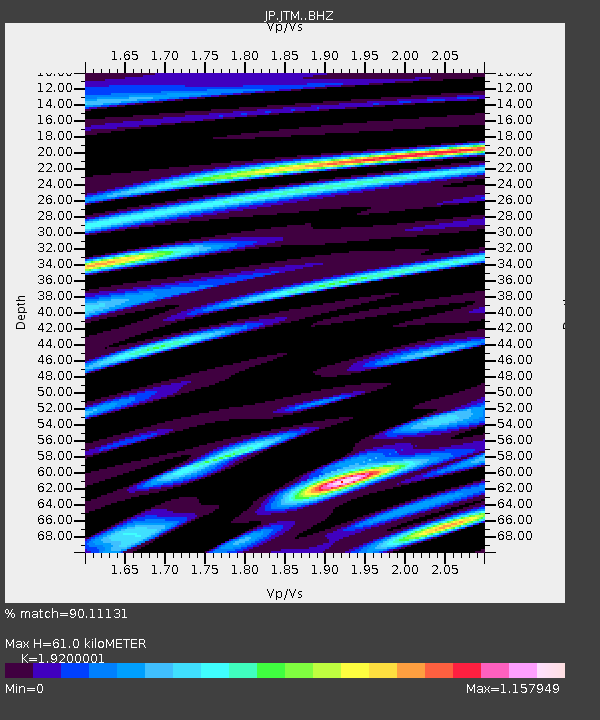
| Estimated Moho Depth: |
61.0 km |
| Estimated Crust Vp/Vs: |
1.92 |
| Assumed Crust Vp: |
6.468 km/s |
| Estimated Crust Vs: |
3.369 km/s |
| Estimated Crust Poisson's Ratio: |
0.31 |
|
| Radial Match: |
90.11131 % |
| Radial Bump: |
400 |
| Transverse Match: |
72.58694 % |
| Transverse Bump: |
400 |
| SOD ConfigId: |
19053131 |
| Insert Time: |
2019-08-14 15:08:25.653 +0000 |
| GWidth: |
2.5 |
| Max Bumps: |
400 |
| Tol: |
0.001 |
|

Signal To Noise
| Channel | StoN | STA | LTA |
| JP:JTM: :BHZ:20190731T15:12:03.400025Z | 33.49839 | 4.553178E-6 | 1.3592229E-7 |
| JP:JTM: :BHN:20190731T15:12:03.400025Z | 10.102747 | 1.7398006E-6 | 1.7221063E-7 |
| JP:JTM: :BHE:20190731T15:12:03.400025Z | 10.946829 | 8.239462E-7 | 7.526803E-8 |
| Arrivals |
| Ps | 9.0 SECOND |
| PpPs | 26 SECOND |
| PsPs/PpSs | 35 SECOND |


