You are here: Home > Network List > TA - USArray Transportable Network (new EarthScope stations) Stations List
> Station N02C Big Bar, CA, USA > Earthquake Result Viewer
N02C Big Bar, CA, USA - Earthquake Result Viewer
| Earthquake location: |
Santa Cruz Islands |
| Earthquake latitude/longitude: |
-11.6/165.8 |
| Earthquake time(UTC): |
2007/09/02 (245) 01:05:18 GMT |
| Earthquake Depth: |
35 km |
| Earthquake Magnitude: |
5.9 MB, 7.3 MS, 7.2 MW, 6.9 ME |
| Earthquake Catalog/Contributor: |
WHDF/NEIC |
|
| Network: |
TA USArray Transportable Network (new EarthScope stations) |
| Station: |
N02C Big Bar, CA, USA |
| Lat/Lon: |
40.82 N/123.31 W |
| Elevation: |
0.0 m |
|
| Distance: |
83.5 deg |
| Az: |
46.209 deg |
| Baz: |
248.746 deg |
| Ray Param: |
0.046075508 |
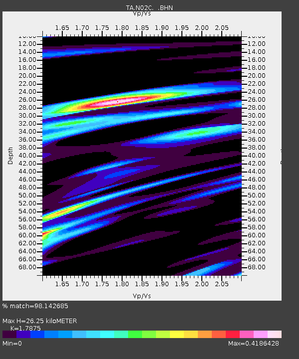
| Estimated Moho Depth: |
26.25 km |
| Estimated Crust Vp/Vs: |
1.79 |
| Assumed Crust Vp: |
6.566 km/s |
| Estimated Crust Vs: |
3.673 km/s |
| Estimated Crust Poisson's Ratio: |
0.27 |
|
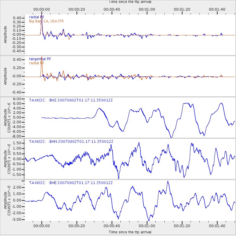
| Radial Match: |
98.142685 % |
| Radial Bump: |
361 |
| Transverse Match: |
86.46072 % |
| Transverse Bump: |
400 |
| SOD ConfigId: |
2564 |
| Insert Time: |
2010-03-07 02:34:14.269 +0000 |
| GWidth: |
2.5 |
| Max Bumps: |
400 |
| Tol: |
0.001 |
|
Signal To Noise
| Channel | StoN | STA | LTA |
| TA:N02C: :BHN:20070902T01:17:11.350012Z | 2.5419157 | 2.8927278E-7 | 1.1380109E-7 |
| TA:N02C: :BHE:20070902T01:17:11.350012Z | 13.791706 | 9.2445293E-7 | 6.702963E-8 |
| TA:N02C: :BHZ:20070902T01:17:11.350012Z | 26.68381 | 2.9059331E-6 | 1.0890249E-7 |
| Arrivals |
| Ps | 3.2 SECOND |
| PpPs | 11 SECOND |
| PsPs/PpSs | 14 SECOND |


