You are here: Home > Network List > TA - USArray Transportable Network (new EarthScope stations) Stations List
> Station N02C Big Bar, CA, USA > Earthquake Result Viewer
N02C Big Bar, CA, USA - Earthquake Result Viewer
| Earthquake location: |
Near Coast Of Peru |
| Earthquake latitude/longitude: |
-13.5/-76.7 |
| Earthquake time(UTC): |
2006/10/20 (293) 10:48:56 GMT |
| Earthquake Depth: |
23 km |
| Earthquake Magnitude: |
5.9 MB, 6.6 MS, 6.7 MW, 6.6 MW |
| Earthquake Catalog/Contributor: |
WHDF/NEIC |
|
| Network: |
TA USArray Transportable Network (new EarthScope stations) |
| Station: |
N02C Big Bar, CA, USA |
| Lat/Lon: |
40.82 N/123.31 W |
| Elevation: |
0.0 m |
|
| Distance: |
69.1 deg |
| Az: |
323.811 deg |
| Baz: |
130.805 deg |
| Ray Param: |
0.05583215 |
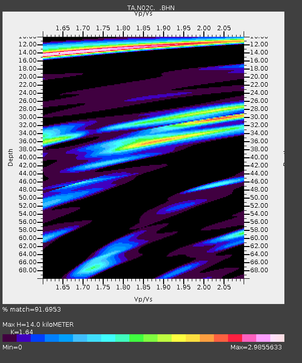
| Estimated Moho Depth: |
14.0 km |
| Estimated Crust Vp/Vs: |
1.64 |
| Assumed Crust Vp: |
6.566 km/s |
| Estimated Crust Vs: |
4.004 km/s |
| Estimated Crust Poisson's Ratio: |
0.20 |
|
| Radial Match: |
91.6953 % |
| Radial Bump: |
400 |
| Transverse Match: |
87.6225 % |
| Transverse Bump: |
400 |
| SOD ConfigId: |
2665 |
| Insert Time: |
2010-03-07 02:34:34.433 +0000 |
| GWidth: |
2.5 |
| Max Bumps: |
400 |
| Tol: |
0.001 |
|
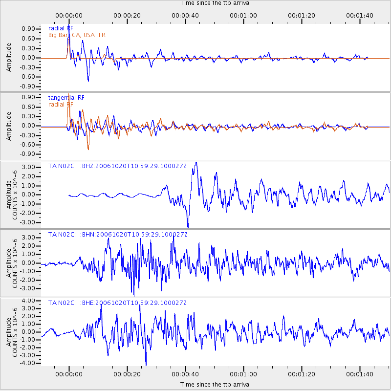
Signal To Noise
| Channel | StoN | STA | LTA |
| TA:N02C: :BHN:20061020T10:59:29.100027Z | 1.8482016 | 2.9968942E-7 | 1.621519E-7 |
| TA:N02C: :BHE:20061020T10:59:29.100027Z | 1.0984654 | 3.48747E-7 | 3.1748564E-7 |
| TA:N02C: :BHZ:20061020T10:59:29.100027Z | 3.7756412 | 5.0908756E-7 | 1.3483474E-7 |
| Arrivals |
| Ps | 1.4 SECOND |
| PpPs | 5.4 SECOND |
| PsPs/PpSs | 6.8 SECOND |


