You are here: Home > Network List > TA - USArray Transportable Network (new EarthScope stations) Stations List
> Station N02C Big Bar, CA, USA > Earthquake Result Viewer
N02C Big Bar, CA, USA - Earthquake Result Viewer
| Earthquake location: |
Fiji Islands Region |
| Earthquake latitude/longitude: |
-19.9/-178.3 |
| Earthquake time(UTC): |
2006/06/27 (178) 02:59:15 GMT |
| Earthquake Depth: |
570 km |
| Earthquake Magnitude: |
6.0 MB, 6.2 MW |
| Earthquake Catalog/Contributor: |
WHDF/NEIC |
|
| Network: |
TA USArray Transportable Network (new EarthScope stations) |
| Station: |
N02C Big Bar, CA, USA |
| Lat/Lon: |
40.82 N/123.31 W |
| Elevation: |
0.0 m |
|
| Distance: |
79.1 deg |
| Az: |
39.275 deg |
| Baz: |
231.732 deg |
| Ray Param: |
0.047470514 |
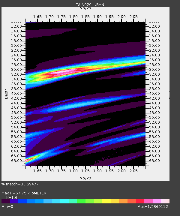
| Estimated Moho Depth: |
67.75 km |
| Estimated Crust Vp/Vs: |
1.60 |
| Assumed Crust Vp: |
6.566 km/s |
| Estimated Crust Vs: |
4.104 km/s |
| Estimated Crust Poisson's Ratio: |
0.18 |
|
| Radial Match: |
83.59477 % |
| Radial Bump: |
400 |
| Transverse Match: |
88.28233 % |
| Transverse Bump: |
400 |
| SOD ConfigId: |
2665 |
| Insert Time: |
2010-03-07 02:34:47.877 +0000 |
| GWidth: |
2.5 |
| Max Bumps: |
400 |
| Tol: |
0.001 |
|
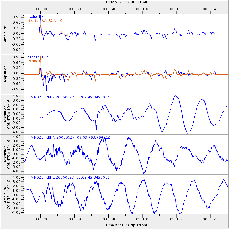
Signal To Noise
| Channel | StoN | STA | LTA |
| TA:N02C: :BHN:20060627T03:09:49.849001Z | 0.8820436 | 8.90568E-7 | 1.0096644E-6 |
| TA:N02C: :BHE:20060627T03:09:49.849001Z | 0.65078014 | 9.132795E-7 | 1.4033611E-6 |
| TA:N02C: :BHZ:20060627T03:09:49.849001Z | 1.8346124 | 1.5336558E-6 | 8.359563E-7 |
| Arrivals |
| Ps | 6.4 SECOND |
| PpPs | 26 SECOND |
| PsPs/PpSs | 32 SECOND |


