You are here: Home > Network List > CU - Caribbean Network (USGS) Stations List
> Station MTDJ Mount Denham, Jamaica > Earthquake Result Viewer
MTDJ Mount Denham, Jamaica - Earthquake Result Viewer
| Earthquake location: |
Southern Chile |
| Earthquake latitude/longitude: |
-43.3/-74.5 |
| Earthquake time(UTC): |
2016/12/25 (360) 14:22:28 GMT |
| Earthquake Depth: |
15 km |
| Earthquake Magnitude: |
7.7 Mi |
| Earthquake Catalog/Contributor: |
NEIC PDE/at |
|
| Network: |
CU Caribbean Network (USGS) |
| Station: |
MTDJ Mount Denham, Jamaica |
| Lat/Lon: |
18.23 N/77.53 W |
| Elevation: |
925 m |
|
| Distance: |
61.3 deg |
| Az: |
356.711 deg |
| Baz: |
177.474 deg |
| Ray Param: |
0.06096206 |
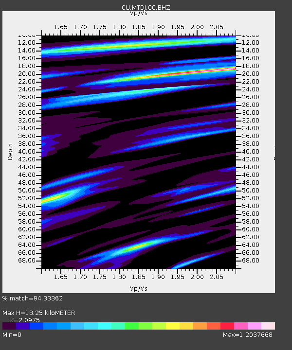
| Estimated Moho Depth: |
18.25 km |
| Estimated Crust Vp/Vs: |
2.10 |
| Assumed Crust Vp: |
4.662 km/s |
| Estimated Crust Vs: |
2.223 km/s |
| Estimated Crust Poisson's Ratio: |
0.35 |
|
| Radial Match: |
94.33362 % |
| Radial Bump: |
325 |
| Transverse Match: |
81.985664 % |
| Transverse Bump: |
400 |
| SOD ConfigId: |
1894071 |
| Insert Time: |
2017-01-08 14:27:38.340 +0000 |
| GWidth: |
2.5 |
| Max Bumps: |
400 |
| Tol: |
0.001 |
|

Signal To Noise
| Channel | StoN | STA | LTA |
| CU:MTDJ:00:BHZ:20161225T14:32:11.474976Z | 25.11972 | 1.6416214E-5 | 6.5351895E-7 |
| CU:MTDJ:00:BH1:20161225T14:32:11.474976Z | 6.918971 | 8.47818E-6 | 1.2253527E-6 |
| CU:MTDJ:00:BH2:20161225T14:32:11.474976Z | 1.3272877 | 1.1685593E-6 | 8.804114E-7 |
| Arrivals |
| Ps | 4.4 SECOND |
| PpPs | 12 SECOND |
| PsPs/PpSs | 16 SECOND |


