You are here: Home > Network List > TA - USArray Transportable Network (new EarthScope stations) Stations List
> Station E27K Coleen River, AK, USA > Earthquake Result Viewer
E27K Coleen River, AK, USA - Earthquake Result Viewer
| Earthquake location: |
Vanuatu Islands |
| Earthquake latitude/longitude: |
-16.2/167.9 |
| Earthquake time(UTC): |
2019/07/31 (212) 15:02:33 GMT |
| Earthquake Depth: |
179 km |
| Earthquake Magnitude: |
6.6 mww |
| Earthquake Catalog/Contributor: |
NEIC PDE/us |
|
| Network: |
TA USArray Transportable Network (new EarthScope stations) |
| Station: |
E27K Coleen River, AK, USA |
| Lat/Lon: |
68.19 N/141.60 W |
| Elevation: |
654 m |
|
| Distance: |
91.6 deg |
| Az: |
16.758 deg |
| Baz: |
227.847 deg |
| Ray Param: |
0.041503154 |
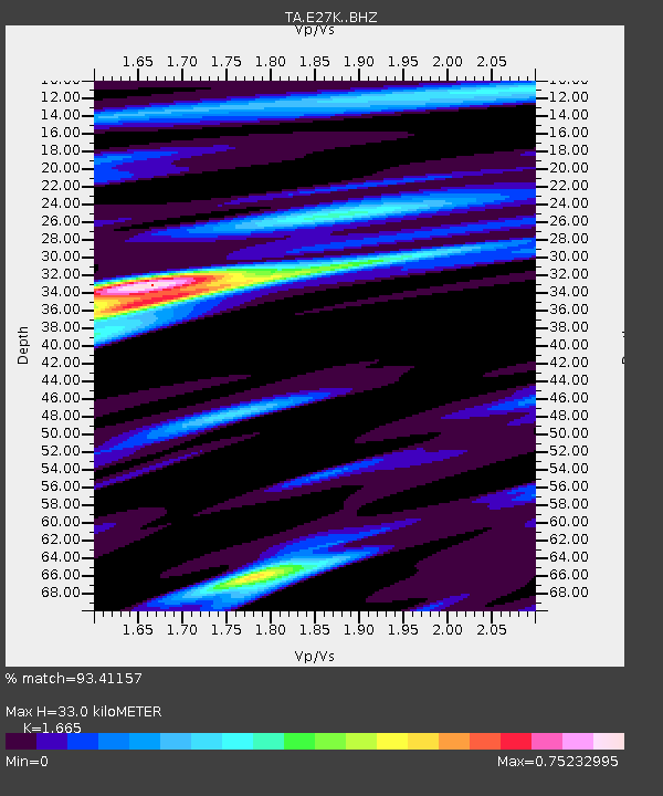
| Estimated Moho Depth: |
33.0 km |
| Estimated Crust Vp/Vs: |
1.66 |
| Assumed Crust Vp: |
6.522 km/s |
| Estimated Crust Vs: |
3.917 km/s |
| Estimated Crust Poisson's Ratio: |
0.22 |
|
| Radial Match: |
93.41157 % |
| Radial Bump: |
400 |
| Transverse Match: |
82.73223 % |
| Transverse Bump: |
400 |
| SOD ConfigId: |
19053131 |
| Insert Time: |
2019-08-14 15:09:57.481 +0000 |
| GWidth: |
2.5 |
| Max Bumps: |
400 |
| Tol: |
0.001 |
|

Signal To Noise
| Channel | StoN | STA | LTA |
| TA:E27K: :BHZ:20190731T15:14:48.825013Z | 10.170751 | 3.65221E-7 | 3.5908954E-8 |
| TA:E27K: :BHN:20190731T15:14:48.825013Z | 2.8793976 | 9.522386E-8 | 3.307076E-8 |
| TA:E27K: :BHE:20190731T15:14:48.825013Z | 2.9305668 | 8.1956514E-8 | 2.7966097E-8 |
| Arrivals |
| Ps | 3.4 SECOND |
| PpPs | 13 SECOND |
| PsPs/PpSs | 17 SECOND |


