You are here: Home > Network List > TA - USArray Transportable Network (new EarthScope stations) Stations List
> Station N02C Big Bar, CA, USA > Earthquake Result Viewer
N02C Big Bar, CA, USA - Earthquake Result Viewer
| Earthquake location: |
Pacific-Antarctic Ridge |
| Earthquake latitude/longitude: |
-54.2/-135.7 |
| Earthquake time(UTC): |
2006/01/24 (024) 04:27:08 GMT |
| Earthquake Depth: |
10 km |
| Earthquake Magnitude: |
4.8 MB, 4.7 MS, 5.5 MW |
| Earthquake Catalog/Contributor: |
WHDF/NEIC |
|
| Network: |
TA USArray Transportable Network (new EarthScope stations) |
| Station: |
N02C Big Bar, CA, USA |
| Lat/Lon: |
40.82 N/123.31 W |
| Elevation: |
0.0 m |
|
| Distance: |
95.2 deg |
| Az: |
9.449 deg |
| Baz: |
187.309 deg |
| Ray Param: |
0.040842496 |
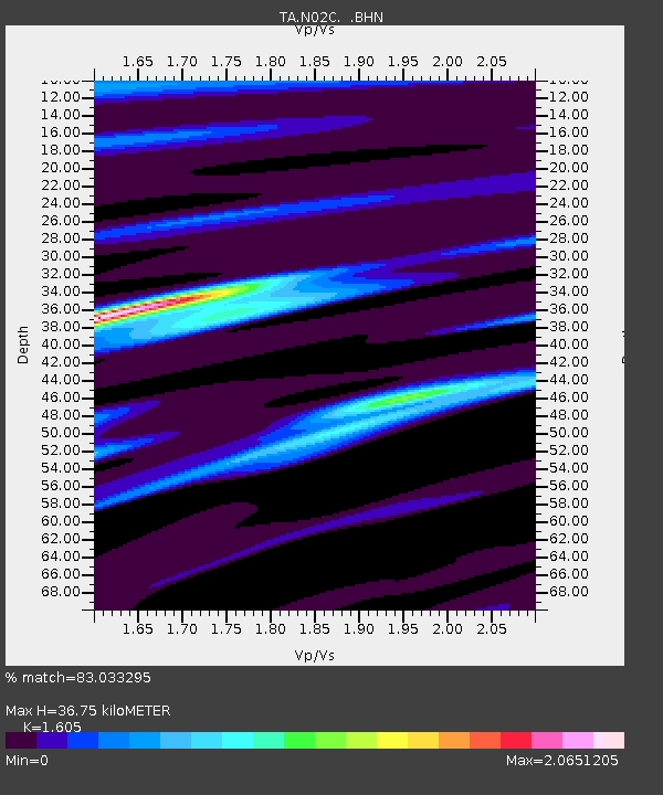
| Estimated Moho Depth: |
36.75 km |
| Estimated Crust Vp/Vs: |
1.61 |
| Assumed Crust Vp: |
6.566 km/s |
| Estimated Crust Vs: |
4.091 km/s |
| Estimated Crust Poisson's Ratio: |
0.18 |
|
| Radial Match: |
83.033295 % |
| Radial Bump: |
400 |
| Transverse Match: |
83.785324 % |
| Transverse Bump: |
400 |
| SOD ConfigId: |
132717 |
| Insert Time: |
2010-03-07 02:35:01.952 +0000 |
| GWidth: |
2.5 |
| Max Bumps: |
400 |
| Tol: |
0.001 |
|
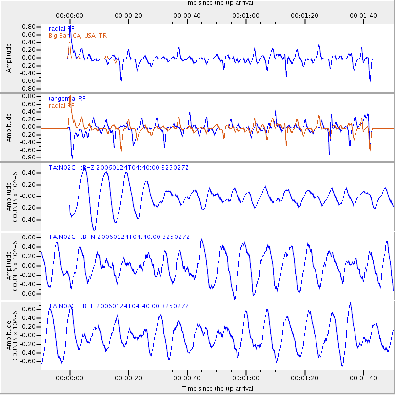
Signal To Noise
| Channel | StoN | STA | LTA |
| TA:N02C: :BHN:20060124T04:40:00.325027Z | 1.1584877 | 2.828162E-7 | 2.4412532E-7 |
| TA:N02C: :BHE:20060124T04:40:00.325027Z | 1.157182 | 3.5549164E-7 | 3.0720463E-7 |
| TA:N02C: :BHZ:20060124T04:40:00.325027Z | 0.33935758 | 1.0542645E-7 | 3.1066477E-7 |
| Arrivals |
| Ps | 3.5 SECOND |
| PpPs | 14 SECOND |
| PsPs/PpSs | 18 SECOND |


