You are here: Home > Network List > TA - USArray Transportable Network (new EarthScope stations) Stations List
> Station N02C Big Bar, CA, USA > Earthquake Result Viewer
N02C Big Bar, CA, USA - Earthquake Result Viewer
| Earthquake location: |
Southeast Of Loyalty Islands |
| Earthquake latitude/longitude: |
-21.5/170.9 |
| Earthquake time(UTC): |
2007/07/27 (208) 14:46:26 GMT |
| Earthquake Depth: |
10 km |
| Earthquake Magnitude: |
6.0 MB, 6.0 MS, 6.1 MW, 6.1 MW |
| Earthquake Catalog/Contributor: |
WHDF/NEIC |
|
| Network: |
TA USArray Transportable Network (new EarthScope stations) |
| Station: |
N02C Big Bar, CA, USA |
| Lat/Lon: |
40.82 N/123.31 W |
| Elevation: |
0.0 m |
|
| Distance: |
86.9 deg |
| Az: |
43.865 deg |
| Baz: |
238.274 deg |
| Ray Param: |
0.043687932 |
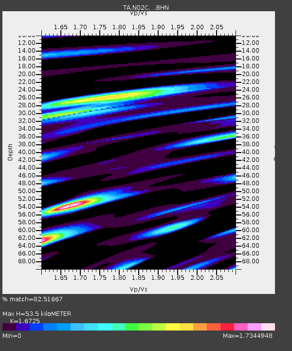
| Estimated Moho Depth: |
53.5 km |
| Estimated Crust Vp/Vs: |
1.67 |
| Assumed Crust Vp: |
6.566 km/s |
| Estimated Crust Vs: |
3.926 km/s |
| Estimated Crust Poisson's Ratio: |
0.22 |
|
| Radial Match: |
82.51667 % |
| Radial Bump: |
400 |
| Transverse Match: |
75.581505 % |
| Transverse Bump: |
400 |
| SOD ConfigId: |
2564 |
| Insert Time: |
2010-03-07 02:35:06.499 +0000 |
| GWidth: |
2.5 |
| Max Bumps: |
400 |
| Tol: |
0.001 |
|
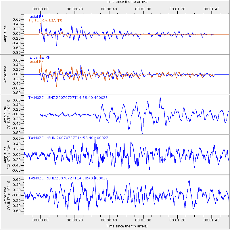
Signal To Noise
| Channel | StoN | STA | LTA |
| TA:N02C: :BHN:20070727T14:58:40.40002Z | 1.0757922 | 7.868589E-8 | 7.3142274E-8 |
| TA:N02C: :BHE:20070727T14:58:40.40002Z | 0.91524935 | 8.64716E-8 | 9.4478736E-8 |
| TA:N02C: :BHZ:20070727T14:58:40.40002Z | 2.7705555 | 1.01988796E-7 | 3.6811677E-8 |
| Arrivals |
| Ps | 5.6 SECOND |
| PpPs | 21 SECOND |
| PsPs/PpSs | 27 SECOND |


