You are here: Home > Network List > TA - USArray Transportable Network (new EarthScope stations) Stations List
> Station I17K Unalakleet, AK, USA > Earthquake Result Viewer
I17K Unalakleet, AK, USA - Earthquake Result Viewer
| Earthquake location: |
Vanuatu Islands |
| Earthquake latitude/longitude: |
-16.2/167.9 |
| Earthquake time(UTC): |
2019/07/31 (212) 15:02:33 GMT |
| Earthquake Depth: |
179 km |
| Earthquake Magnitude: |
6.6 mww |
| Earthquake Catalog/Contributor: |
NEIC PDE/us |
|
| Network: |
TA USArray Transportable Network (new EarthScope stations) |
| Station: |
I17K Unalakleet, AK, USA |
| Lat/Lon: |
63.89 N/160.70 W |
| Elevation: |
105 m |
|
| Distance: |
83.4 deg |
| Az: |
13.405 deg |
| Baz: |
210.227 deg |
| Ray Param: |
0.045790177 |
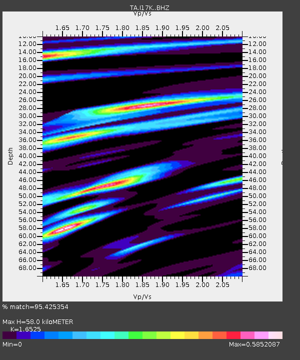
| Estimated Moho Depth: |
58.0 km |
| Estimated Crust Vp/Vs: |
1.65 |
| Assumed Crust Vp: |
6.276 km/s |
| Estimated Crust Vs: |
3.798 km/s |
| Estimated Crust Poisson's Ratio: |
0.21 |
|
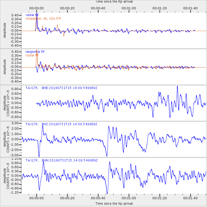
| Radial Match: |
95.425354 % |
| Radial Bump: |
400 |
| Transverse Match: |
83.70681 % |
| Transverse Bump: |
400 |
| SOD ConfigId: |
19053131 |
| Insert Time: |
2019-08-14 15:10:22.832 +0000 |
| GWidth: |
2.5 |
| Max Bumps: |
400 |
| Tol: |
0.001 |
|
Signal To Noise
| Channel | StoN | STA | LTA |
| TA:I17K: :BHZ:20190731T15:14:09.549989Z | 10.225509 | 1.4805208E-6 | 1.4478702E-7 |
| TA:I17K: :BHN:20190731T15:14:09.549989Z | 5.138107 | 5.290404E-7 | 1.0296407E-7 |
| TA:I17K: :BHE:20190731T15:14:09.549989Z | 2.006831 | 2.0589337E-7 | 1.02596275E-7 |
| Arrivals |
| Ps | 6.2 SECOND |
| PpPs | 24 SECOND |
| PsPs/PpSs | 30 SECOND |


