You are here: Home > Network List > TA - USArray Transportable Network (new EarthScope stations) Stations List
> Station I27K Kandik River, AK, USA > Earthquake Result Viewer
I27K Kandik River, AK, USA - Earthquake Result Viewer
| Earthquake location: |
Vanuatu Islands |
| Earthquake latitude/longitude: |
-16.2/167.9 |
| Earthquake time(UTC): |
2019/07/31 (212) 15:02:33 GMT |
| Earthquake Depth: |
179 km |
| Earthquake Magnitude: |
6.6 mww |
| Earthquake Catalog/Contributor: |
NEIC PDE/us |
|
| Network: |
TA USArray Transportable Network (new EarthScope stations) |
| Station: |
I27K Kandik River, AK, USA |
| Lat/Lon: |
65.60 N/141.62 W |
| Elevation: |
874 m |
|
| Distance: |
89.9 deg |
| Az: |
18.676 deg |
| Baz: |
227.804 deg |
| Ray Param: |
0.04167639 |
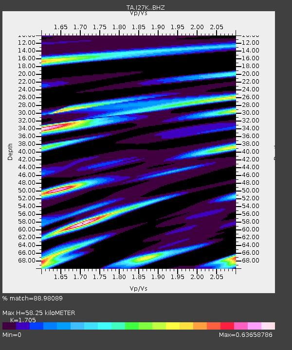
| Estimated Moho Depth: |
58.25 km |
| Estimated Crust Vp/Vs: |
1.71 |
| Assumed Crust Vp: |
6.566 km/s |
| Estimated Crust Vs: |
3.851 km/s |
| Estimated Crust Poisson's Ratio: |
0.24 |
|
| Radial Match: |
88.98089 % |
| Radial Bump: |
400 |
| Transverse Match: |
78.90971 % |
| Transverse Bump: |
400 |
| SOD ConfigId: |
19053131 |
| Insert Time: |
2019-08-14 15:10:25.071 +0000 |
| GWidth: |
2.5 |
| Max Bumps: |
400 |
| Tol: |
0.001 |
|

Signal To Noise
| Channel | StoN | STA | LTA |
| TA:I27K: :BHZ:20190731T15:14:40.750001Z | 10.7726145 | 4.156173E-7 | 3.8580914E-8 |
| TA:I27K: :BHN:20190731T15:14:40.750001Z | 2.8360374 | 1.0279032E-7 | 3.6244344E-8 |
| TA:I27K: :BHE:20190731T15:14:40.750001Z | 2.8041131 | 1.1321887E-7 | 4.0375998E-8 |
| Arrivals |
| Ps | 6.4 SECOND |
| PpPs | 23 SECOND |
| PsPs/PpSs | 30 SECOND |


