You are here: Home > Network List > TA - USArray Transportable Network (new EarthScope stations) Stations List
> Station J30M Hart River, Yukon, CAN > Earthquake Result Viewer
J30M Hart River, Yukon, CAN - Earthquake Result Viewer
| Earthquake location: |
Vanuatu Islands |
| Earthquake latitude/longitude: |
-16.2/167.9 |
| Earthquake time(UTC): |
2019/07/31 (212) 15:02:33 GMT |
| Earthquake Depth: |
179 km |
| Earthquake Magnitude: |
6.6 mww |
| Earthquake Catalog/Contributor: |
NEIC PDE/us |
|
| Network: |
TA USArray Transportable Network (new EarthScope stations) |
| Station: |
J30M Hart River, Yukon, CAN |
| Lat/Lon: |
64.58 N/136.33 W |
| Elevation: |
1419 m |
|
| Distance: |
90.9 deg |
| Az: |
20.901 deg |
| Baz: |
232.577 deg |
| Ray Param: |
0.041600965 |
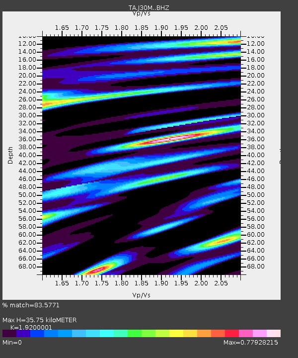
| Estimated Moho Depth: |
35.75 km |
| Estimated Crust Vp/Vs: |
1.92 |
| Assumed Crust Vp: |
6.566 km/s |
| Estimated Crust Vs: |
3.42 km/s |
| Estimated Crust Poisson's Ratio: |
0.31 |
|
| Radial Match: |
83.5771 % |
| Radial Bump: |
400 |
| Transverse Match: |
68.094696 % |
| Transverse Bump: |
400 |
| SOD ConfigId: |
19053131 |
| Insert Time: |
2019-08-14 15:10:33.087 +0000 |
| GWidth: |
2.5 |
| Max Bumps: |
400 |
| Tol: |
0.001 |
|

Signal To Noise
| Channel | StoN | STA | LTA |
| TA:J30M: :BHZ:20190731T15:14:45.650025Z | 5.1775227 | 2.4743863E-7 | 4.7790934E-8 |
| TA:J30M: :BHN:20190731T15:14:45.650025Z | 1.5973344 | 4.607108E-8 | 2.8842479E-8 |
| TA:J30M: :BHE:20190731T15:14:45.650025Z | 2.1842418 | 7.382085E-8 | 3.3797015E-8 |
| Arrivals |
| Ps | 5.1 SECOND |
| PpPs | 16 SECOND |
| PsPs/PpSs | 21 SECOND |


