You are here: Home > Network List > TA - USArray Transportable Network (new EarthScope stations) Stations List
> Station M13K Dall Lake, AK, USA > Earthquake Result Viewer
M13K Dall Lake, AK, USA - Earthquake Result Viewer
| Earthquake location: |
Vanuatu Islands |
| Earthquake latitude/longitude: |
-16.2/167.9 |
| Earthquake time(UTC): |
2019/07/31 (212) 15:02:33 GMT |
| Earthquake Depth: |
179 km |
| Earthquake Magnitude: |
6.6 mww |
| Earthquake Catalog/Contributor: |
NEIC PDE/us |
|
| Network: |
TA USArray Transportable Network (new EarthScope stations) |
| Station: |
M13K Dall Lake, AK, USA |
| Lat/Lon: |
60.41 N/163.35 W |
| Elevation: |
9.0 m |
|
| Distance: |
79.7 deg |
| Az: |
14.017 deg |
| Baz: |
207.971 deg |
| Ray Param: |
0.0483134 |
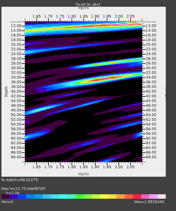
| Estimated Moho Depth: |
10.75 km |
| Estimated Crust Vp/Vs: |
2.08 |
| Assumed Crust Vp: |
6.1 km/s |
| Estimated Crust Vs: |
2.933 km/s |
| Estimated Crust Poisson's Ratio: |
0.35 |
|
| Radial Match: |
86.01075 % |
| Radial Bump: |
400 |
| Transverse Match: |
81.63811 % |
| Transverse Bump: |
400 |
| SOD ConfigId: |
19053131 |
| Insert Time: |
2019-08-14 15:10:42.672 +0000 |
| GWidth: |
2.5 |
| Max Bumps: |
400 |
| Tol: |
0.001 |
|

Signal To Noise
| Channel | StoN | STA | LTA |
| TA:M13K: :BHZ:20190731T15:13:50.474977Z | 7.6207414 | 1.7482114E-6 | 2.2940176E-7 |
| TA:M13K: :BHN:20190731T15:13:50.474977Z | 2.133669 | 5.0149407E-7 | 2.3503836E-7 |
| TA:M13K: :BHE:20190731T15:13:50.474977Z | 1.5270941 | 3.5696837E-7 | 2.3375664E-7 |
| Arrivals |
| Ps | 1.9 SECOND |
| PpPs | 5.3 SECOND |
| PsPs/PpSs | 7.3 SECOND |


