You are here: Home > Network List > TA - USArray Transportable Network (new EarthScope stations) Stations List
> Station M16K Timber Creek, AK, USA > Earthquake Result Viewer
M16K Timber Creek, AK, USA - Earthquake Result Viewer
| Earthquake location: |
Vanuatu Islands |
| Earthquake latitude/longitude: |
-16.2/167.9 |
| Earthquake time(UTC): |
2019/07/31 (212) 15:02:33 GMT |
| Earthquake Depth: |
179 km |
| Earthquake Magnitude: |
6.6 mww |
| Earthquake Catalog/Contributor: |
NEIC PDE/us |
|
| Network: |
TA USArray Transportable Network (new EarthScope stations) |
| Station: |
M16K Timber Creek, AK, USA |
| Lat/Lon: |
61.02 N/158.96 W |
| Elevation: |
394 m |
|
| Distance: |
81.4 deg |
| Az: |
15.602 deg |
| Baz: |
212.056 deg |
| Ray Param: |
0.047209226 |
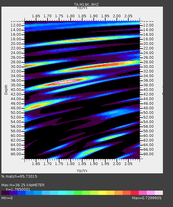
| Estimated Moho Depth: |
36.25 km |
| Estimated Crust Vp/Vs: |
1.79 |
| Assumed Crust Vp: |
6.276 km/s |
| Estimated Crust Vs: |
3.516 km/s |
| Estimated Crust Poisson's Ratio: |
0.27 |
|
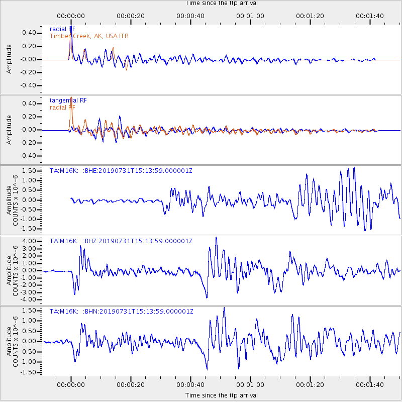
| Radial Match: |
95.73015 % |
| Radial Bump: |
400 |
| Transverse Match: |
89.6528 % |
| Transverse Bump: |
400 |
| SOD ConfigId: |
19053131 |
| Insert Time: |
2019-08-14 15:10:44.440 +0000 |
| GWidth: |
2.5 |
| Max Bumps: |
400 |
| Tol: |
0.001 |
|
Signal To Noise
| Channel | StoN | STA | LTA |
| TA:M16K: :BHZ:20190731T15:13:59.000001Z | 31.004158 | 1.7976679E-6 | 5.798151E-8 |
| TA:M16K: :BHN:20190731T15:13:59.000001Z | 11.379973 | 5.5404644E-7 | 4.8686093E-8 |
| TA:M16K: :BHE:20190731T15:13:59.000001Z | 6.6915026 | 4.0018807E-7 | 5.9805416E-8 |
| Arrivals |
| Ps | 4.7 SECOND |
| PpPs | 16 SECOND |
| PsPs/PpSs | 20 SECOND |


