You are here: Home > Network List > TA - USArray Transportable Network (new EarthScope stations) Stations List
> Station P23K Montague Island, AK, USA > Earthquake Result Viewer
P23K Montague Island, AK, USA - Earthquake Result Viewer
| Earthquake location: |
Vanuatu Islands |
| Earthquake latitude/longitude: |
-16.2/167.9 |
| Earthquake time(UTC): |
2019/07/31 (212) 15:02:33 GMT |
| Earthquake Depth: |
179 km |
| Earthquake Magnitude: |
6.6 mww |
| Earthquake Catalog/Contributor: |
NEIC PDE/us |
|
| Network: |
TA USArray Transportable Network (new EarthScope stations) |
| Station: |
P23K Montague Island, AK, USA |
| Lat/Lon: |
60.00 N/147.40 W |
| Elevation: |
287 m |
|
| Distance: |
84.0 deg |
| Az: |
20.801 deg |
| Baz: |
222.77 deg |
| Ray Param: |
0.045362886 |
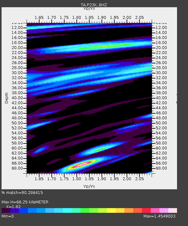
| Estimated Moho Depth: |
66.25 km |
| Estimated Crust Vp/Vs: |
1.82 |
| Assumed Crust Vp: |
5.989 km/s |
| Estimated Crust Vs: |
3.291 km/s |
| Estimated Crust Poisson's Ratio: |
0.28 |
|
| Radial Match: |
90.286415 % |
| Radial Bump: |
400 |
| Transverse Match: |
87.504524 % |
| Transverse Bump: |
400 |
| SOD ConfigId: |
19053131 |
| Insert Time: |
2019-08-14 15:11:05.627 +0000 |
| GWidth: |
2.5 |
| Max Bumps: |
400 |
| Tol: |
0.001 |
|

Signal To Noise
| Channel | StoN | STA | LTA |
| TA:P23K: :BHZ:20190731T15:14:12.650025Z | 10.5211525 | 1.2250018E-6 | 1.16432275E-7 |
| TA:P23K: :BHN:20190731T15:14:12.650025Z | 3.203656 | 3.256276E-7 | 1.01642506E-7 |
| TA:P23K: :BHE:20190731T15:14:12.650025Z | 1.7123622 | 2.1491661E-7 | 1.2550885E-7 |
| Arrivals |
| Ps | 9.3 SECOND |
| PpPs | 31 SECOND |
| PsPs/PpSs | 40 SECOND |


