You are here: Home > Network List > TA - USArray Transportable Network (new EarthScope stations) Stations List
> Station S12K Black Hills, AK, USA > Earthquake Result Viewer
S12K Black Hills, AK, USA - Earthquake Result Viewer
| Earthquake location: |
Vanuatu Islands |
| Earthquake latitude/longitude: |
-16.2/167.9 |
| Earthquake time(UTC): |
2019/07/31 (212) 15:02:33 GMT |
| Earthquake Depth: |
179 km |
| Earthquake Magnitude: |
6.6 mww |
| Earthquake Catalog/Contributor: |
NEIC PDE/us |
|
| Network: |
TA USArray Transportable Network (new EarthScope stations) |
| Station: |
S12K Black Hills, AK, USA |
| Lat/Lon: |
55.70 N/162.06 W |
| Elevation: |
411 m |
|
| Distance: |
75.9 deg |
| Az: |
16.961 deg |
| Baz: |
209.685 deg |
| Ray Param: |
0.050874975 |
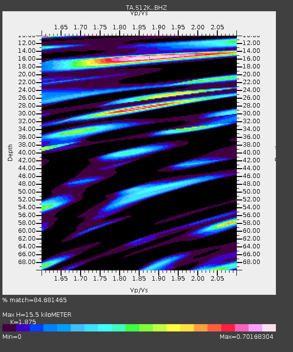
| Estimated Moho Depth: |
15.5 km |
| Estimated Crust Vp/Vs: |
1.88 |
| Assumed Crust Vp: |
5.989 km/s |
| Estimated Crust Vs: |
3.194 km/s |
| Estimated Crust Poisson's Ratio: |
0.30 |
|
| Radial Match: |
84.681465 % |
| Radial Bump: |
400 |
| Transverse Match: |
60.696922 % |
| Transverse Bump: |
400 |
| SOD ConfigId: |
19053131 |
| Insert Time: |
2019-08-14 15:11:17.211 +0000 |
| GWidth: |
2.5 |
| Max Bumps: |
400 |
| Tol: |
0.001 |
|

Signal To Noise
| Channel | StoN | STA | LTA |
| TA:S12K: :BHZ:20190731T15:13:29.549989Z | 6.3224416 | 1.5209934E-6 | 2.4057056E-7 |
| TA:S12K: :BHN:20190731T15:13:29.549989Z | 2.3205416 | 5.3477004E-7 | 2.3045052E-7 |
| TA:S12K: :BHE:20190731T15:13:29.549989Z | 1.129888 | 2.4041327E-7 | 2.127762E-7 |
| Arrivals |
| Ps | 2.3 SECOND |
| PpPs | 7.3 SECOND |
| PsPs/PpSs | 9.6 SECOND |


