You are here: Home > Network List > UO - University of Oregon Regional Network Stations List
> Station MARQ Marquam, OR, USA > Earthquake Result Viewer
MARQ Marquam, OR, USA - Earthquake Result Viewer
| Earthquake location: |
Vanuatu Islands |
| Earthquake latitude/longitude: |
-16.2/167.9 |
| Earthquake time(UTC): |
2019/07/31 (212) 15:02:33 GMT |
| Earthquake Depth: |
179 km |
| Earthquake Magnitude: |
6.6 mww |
| Earthquake Catalog/Contributor: |
NEIC PDE/us |
|
| Network: |
UO University of Oregon Regional Network |
| Station: |
MARQ Marquam, OR, USA |
| Lat/Lon: |
45.07 N/122.67 W |
| Elevation: |
159 m |
|
| Distance: |
87.4 deg |
| Az: |
41.602 deg |
| Baz: |
244.201 deg |
| Ray Param: |
0.04290842 |
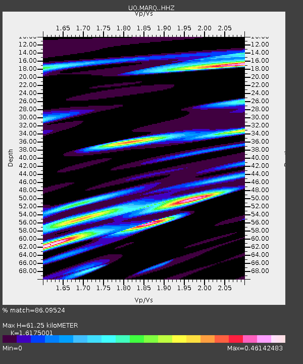
| Estimated Moho Depth: |
61.25 km |
| Estimated Crust Vp/Vs: |
1.62 |
| Assumed Crust Vp: |
6.566 km/s |
| Estimated Crust Vs: |
4.059 km/s |
| Estimated Crust Poisson's Ratio: |
0.19 |
|
| Radial Match: |
86.09524 % |
| Radial Bump: |
400 |
| Transverse Match: |
84.09578 % |
| Transverse Bump: |
400 |
| SOD ConfigId: |
19053131 |
| Insert Time: |
2019-08-14 15:11:40.864 +0000 |
| GWidth: |
2.5 |
| Max Bumps: |
400 |
| Tol: |
0.001 |
|

Signal To Noise
| Channel | StoN | STA | LTA |
| UO:MARQ: :HHZ:20190731T15:14:29.479981Z | 5.7742343 | 7.7738065E-7 | 1.3462922E-7 |
| UO:MARQ: :HHN:20190731T15:14:29.479981Z | 1.1249565 | 1.5046709E-7 | 1.337537E-7 |
| UO:MARQ: :HHE:20190731T15:14:29.479981Z | 2.719943 | 3.2442352E-7 | 1.1927585E-7 |
| Arrivals |
| Ps | 5.9 SECOND |
| PpPs | 24 SECOND |
| PsPs/PpSs | 30 SECOND |


