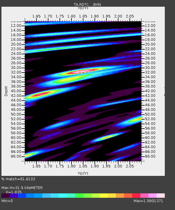
R07C Lee Vining, CA, USA - Earthquake Result Viewer
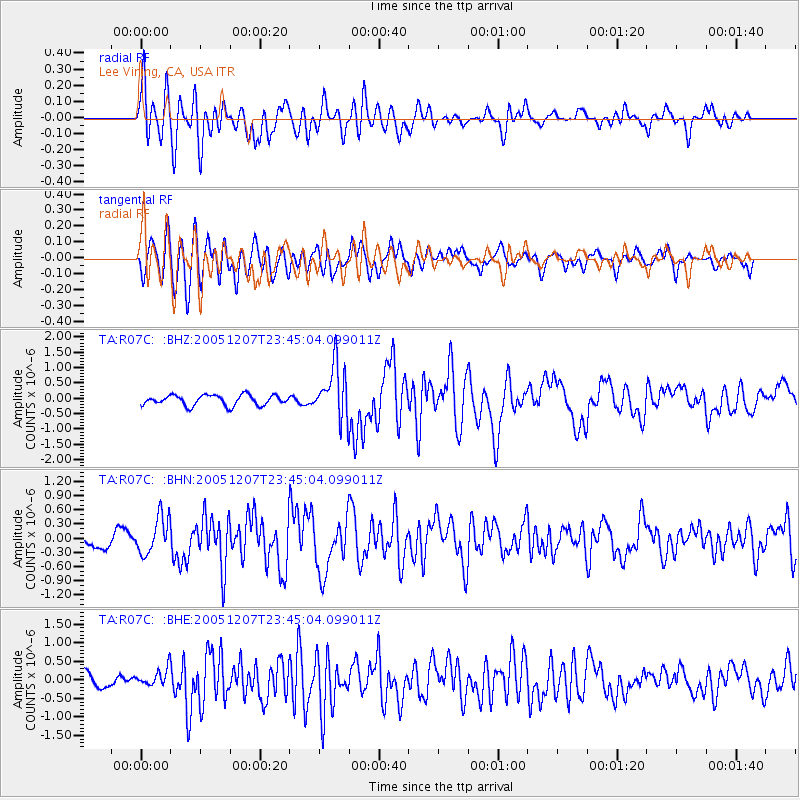
Earthquake location: Kermadec Islands, New Zealand
Earthquake latitude/longitude: -30.0/-177.6
Earthquake time(UTC): 2005/12/07 (341) 23:32:51 GMT
Earthquake Depth: 21 km
Earthquake Magnitude: 6.0 MB, 6.4 MS, 6.4 MW, 6.3 MW
Earthquake Catalog/Contributor: WHDF/NEIC
Network: TA USArray Transportable Network (new EarthScope stations)
Station: R07C Lee Vining, CA, USA
Lat/Lon: 38.09 N/119.05 W
Elevation: 1996 m
Distance: 87.1 deg
Az: 42.4 deg
Baz: 227.836 deg
Ray Param: 0.043564163
Estimated Moho Depth: 31.5 km
Estimated Crust Vp/Vs: 1.84
Assumed Crust Vp: 6.279 km/s
Estimated Crust Vs: 3.422 km/s
Estimated Crust Poisson's Ratio: 0.29
Radial Match: 81.6102 %
Radial Bump: 400
Transverse Match: 78.228615 %
Transverse Bump: 400
SOD ConfigId: 2564
Insert Time: 2010-03-07 02:35:36.835 +0000
GWidth: 2.5
Max Bumps: 400
Tol: 0.001

Signal To Noise

ChannelStoNSTALTA
TA:R07C: :BHN:20051207T23:45:04.099011Z1.96137733.9421167E-72.0098716E-7
TA:R07C: :BHE:20051207T23:45:04.099011Z1.18607752.3232334E-71.9587534E-7
TA:R07C: :BHZ:20051207T23:45:04.099011Z5.2495848.720648E-71.6612074E-7
Arrivals
Ps4.3 SECOND
PpPs14 SECOND
PsPs/PpSs18 SECOND