You are here: Home > Network List > US - United States National Seismic Network Stations List
> Station MSO Missoula, Montana, USA > Earthquake Result Viewer
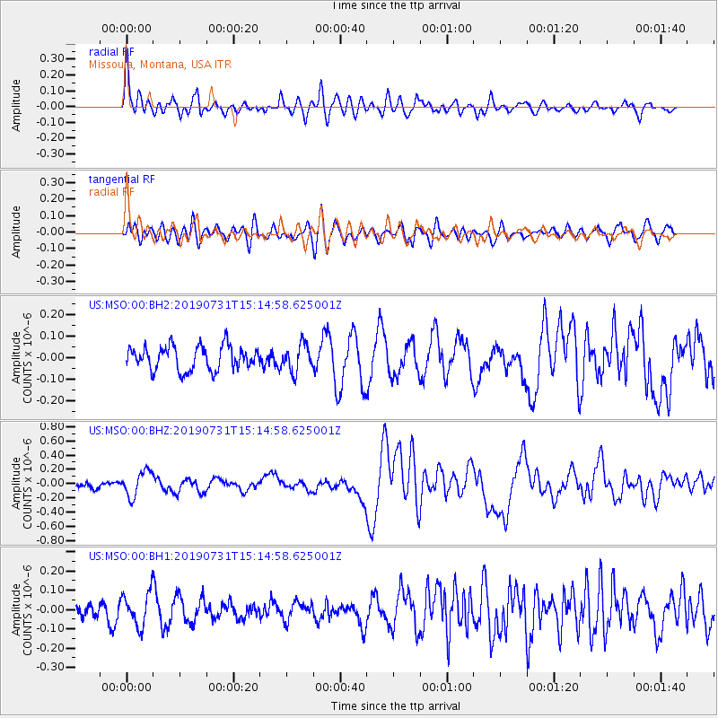
MSO Missoula, Montana, USA - Earthquake Result Viewer
*The percent match for this event was below the threshold and hence no stack was calculated.
| Earthquake location: |
Vanuatu Islands |
| Earthquake latitude/longitude: |
-16.2/167.9 |
| Earthquake time(UTC): |
2019/07/31 (212) 15:02:33 GMT |
| Earthquake Depth: |
179 km |
| Earthquake Magnitude: |
6.6 mww |
| Earthquake Catalog/Contributor: |
NEIC PDE/us |
|
| Network: |
US United States National Seismic Network |
| Station: |
MSO Missoula, Montana, USA |
| Lat/Lon: |
46.83 N/113.94 W |
| Elevation: |
1264 m |
|
| Distance: |
93.7 deg |
| Az: |
42.324 deg |
| Baz: |
250.453 deg |
| Ray Param: |
$rayparam |
*The percent match for this event was below the threshold and hence was not used in the summary stack. |
|
| Radial Match: |
66.432755 % |
| Radial Bump: |
400 |
| Transverse Match: |
54.155304 % |
| Transverse Bump: |
400 |
| SOD ConfigId: |
19053131 |
| Insert Time: |
2019-08-14 15:11:52.995 +0000 |
| GWidth: |
2.5 |
| Max Bumps: |
400 |
| Tol: |
0.001 |
|
Signal To Noise
| Channel | StoN | STA | LTA |
| US:MSO:00:BHZ:20190731T15:14:58.625001Z | 2.7336411 | 1.7924758E-7 | 6.5570994E-8 |
| US:MSO:00:BH1:20190731T15:14:58.625001Z | 1.4982631 | 8.722341E-8 | 5.821635E-8 |
| US:MSO:00:BH2:20190731T15:14:58.625001Z | 1.1319193 | 6.268368E-8 | 5.5378226E-8 |
| Arrivals |
| Ps | |
| PpPs | |
| PsPs/PpSs | |


