You are here: Home > Network List > TA - USArray Transportable Network (new EarthScope stations) Stations List
> Station R07C Lee Vining, CA, USA > Earthquake Result Viewer
R07C Lee Vining, CA, USA - Earthquake Result Viewer
| Earthquake location: |
Chile-Bolivia Border Region |
| Earthquake latitude/longitude: |
-22.3/-67.9 |
| Earthquake time(UTC): |
2005/11/17 (321) 19:26:56 GMT |
| Earthquake Depth: |
163 km |
| Earthquake Magnitude: |
6.0 MB, 6.9 MW, 6.8 MW |
| Earthquake Catalog/Contributor: |
WHDF/NEIC |
|
| Network: |
TA USArray Transportable Network (new EarthScope stations) |
| Station: |
R07C Lee Vining, CA, USA |
| Lat/Lon: |
38.09 N/119.05 W |
| Elevation: |
1996 m |
|
| Distance: |
76.9 deg |
| Az: |
320.879 deg |
| Baz: |
132.231 deg |
| Ray Param: |
0.050264128 |
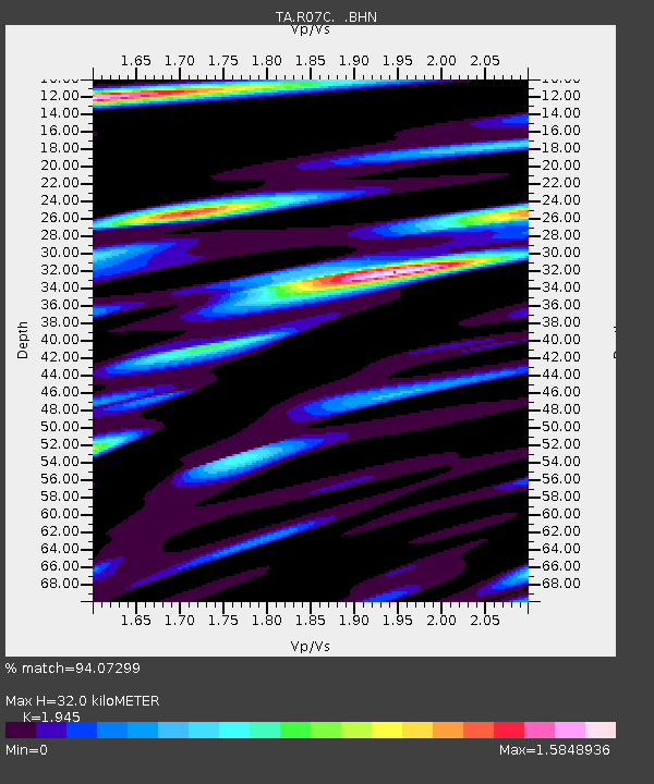
| Estimated Moho Depth: |
32.0 km |
| Estimated Crust Vp/Vs: |
1.95 |
| Assumed Crust Vp: |
6.279 km/s |
| Estimated Crust Vs: |
3.228 km/s |
| Estimated Crust Poisson's Ratio: |
0.32 |
|
| Radial Match: |
94.07299 % |
| Radial Bump: |
400 |
| Transverse Match: |
88.56751 % |
| Transverse Bump: |
400 |
| SOD ConfigId: |
2422 |
| Insert Time: |
2010-03-07 02:35:41.731 +0000 |
| GWidth: |
2.5 |
| Max Bumps: |
400 |
| Tol: |
0.001 |
|

Signal To Noise
| Channel | StoN | STA | LTA |
| TA:R07C: :BHN:20051117T19:37:59.773994Z | 3.5749667 | 6.538313E-7 | 1.8289158E-7 |
| TA:R07C: :BHE:20051117T19:37:59.773994Z | 3.3670988 | 7.264829E-7 | 2.157593E-7 |
| TA:R07C: :BHZ:20051117T19:37:59.773994Z | 21.440372 | 3.1464174E-6 | 1.4675199E-7 |
| Arrivals |
| Ps | 4.9 SECOND |
| PpPs | 15 SECOND |
| PsPs/PpSs | 20 SECOND |


