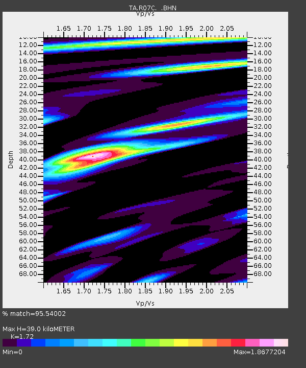
R07C Lee Vining, CA, USA - Earthquake Result Viewer

Earthquake location: Near East Coast Of Honshu, Japan
Earthquake latitude/longitude: 38.3/142.0
Earthquake time(UTC): 2005/08/16 (228) 02:46:28 GMT
Earthquake Depth: 36 km
Earthquake Magnitude: 6.5 MB, 6.8 MS, 7.2 MW, 7.1 MW
Earthquake Catalog/Contributor: WHDF/NEIC
Network: TA USArray Transportable Network (new EarthScope stations)
Station: R07C Lee Vining, CA, USA
Lat/Lon: 38.09 N/119.05 W
Elevation: 1996 m
Distance: 73.6 deg
Az: 54.359 deg
Baz: 305.843 deg
Ray Param: 0.052856296
Estimated Moho Depth: 39.0 km
Estimated Crust Vp/Vs: 1.72
Assumed Crust Vp: 6.279 km/s
Estimated Crust Vs: 3.65 km/s
Estimated Crust Poisson's Ratio: 0.24
Radial Match: 95.54002 %
Radial Bump: 400
Transverse Match: 84.22103 %
Transverse Bump: 400
SOD ConfigId: 2475
Insert Time: 2010-03-07 02:35:53.987 +0000
GWidth: 2.5
Max Bumps: 400
Tol: 0.001

Signal To Noise

ChannelStoNSTALTA
TA:R07C: :BHN:20050816T02:57:26.873999Z2.30082682.452537E-71.0659372E-7
TA:R07C: :BHE:20050816T02:57:26.873999Z2.0124062.8188646E-71.4007433E-7
TA:R07C: :BHZ:20050816T02:57:26.873999Z7.9137715.9678746E-77.541126E-8
Arrivals
Ps4.6 SECOND
PpPs16 SECOND
PsPs/PpSs21 SECOND