You are here: Home > Network List > UW - Pacific Northwest Regional Seismic Network Stations List
> Station FISH Seaside, OR, USA > Earthquake Result Viewer
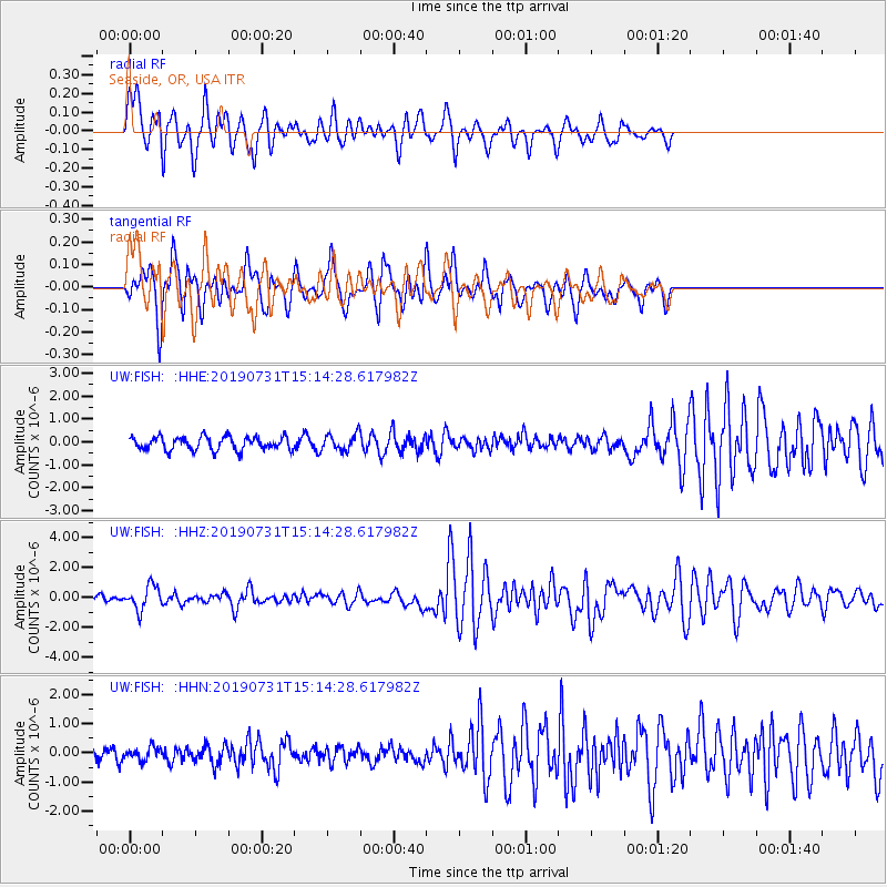
FISH Seaside, OR, USA - Earthquake Result Viewer
*The percent match for this event was below the threshold and hence no stack was calculated.
| Earthquake location: |
Vanuatu Islands |
| Earthquake latitude/longitude: |
-16.2/167.9 |
| Earthquake time(UTC): |
2019/07/31 (212) 15:02:33 GMT |
| Earthquake Depth: |
179 km |
| Earthquake Magnitude: |
6.6 mww |
| Earthquake Catalog/Contributor: |
NEIC PDE/us |
|
| Network: |
UW Pacific Northwest Regional Seismic Network |
| Station: |
FISH Seaside, OR, USA |
| Lat/Lon: |
45.93 N/123.56 W |
| Elevation: |
325 m |
|
| Distance: |
87.3 deg |
| Az: |
40.548 deg |
| Baz: |
243.52 deg |
| Ray Param: |
$rayparam |
*The percent match for this event was below the threshold and hence was not used in the summary stack. |
|
| Radial Match: |
77.75932 % |
| Radial Bump: |
400 |
| Transverse Match: |
76.30346 % |
| Transverse Bump: |
400 |
| SOD ConfigId: |
19053131 |
| Insert Time: |
2019-08-14 15:12:16.151 +0000 |
| GWidth: |
2.5 |
| Max Bumps: |
400 |
| Tol: |
0.001 |
|
Signal To Noise
| Channel | StoN | STA | LTA |
| UW:FISH: :HHZ:20190731T15:14:28.617982Z | 4.039156 | 7.7316116E-7 | 1.9141652E-7 |
| UW:FISH: :HHN:20190731T15:14:28.617982Z | 0.6309392 | 2.186893E-7 | 3.4660914E-7 |
| UW:FISH: :HHE:20190731T15:14:28.617982Z | 1.2637775 | 3.670761E-7 | 2.9045944E-7 |
| Arrivals |
| Ps | |
| PpPs | |
| PsPs/PpSs | |


