You are here: Home > Network List > TA - USArray Transportable Network (new EarthScope stations) Stations List
> Station R07C Lee Vining, CA, USA > Earthquake Result Viewer
R07C Lee Vining, CA, USA - Earthquake Result Viewer
| Earthquake location: |
Solomon Islands |
| Earthquake latitude/longitude: |
-9.8/159.5 |
| Earthquake time(UTC): |
2007/08/16 (228) 08:39:27 GMT |
| Earthquake Depth: |
10 km |
| Earthquake Magnitude: |
6.1 MB, 6.7 MS, 6.4 MW |
| Earthquake Catalog/Contributor: |
WHDF/NEIC |
|
| Network: |
TA USArray Transportable Network (new EarthScope stations) |
| Station: |
R07C Lee Vining, CA, USA |
| Lat/Lon: |
38.09 N/119.05 W |
| Elevation: |
1996 m |
|
| Distance: |
89.4 deg |
| Az: |
51.298 deg |
| Baz: |
257.086 deg |
| Ray Param: |
0.041896895 |
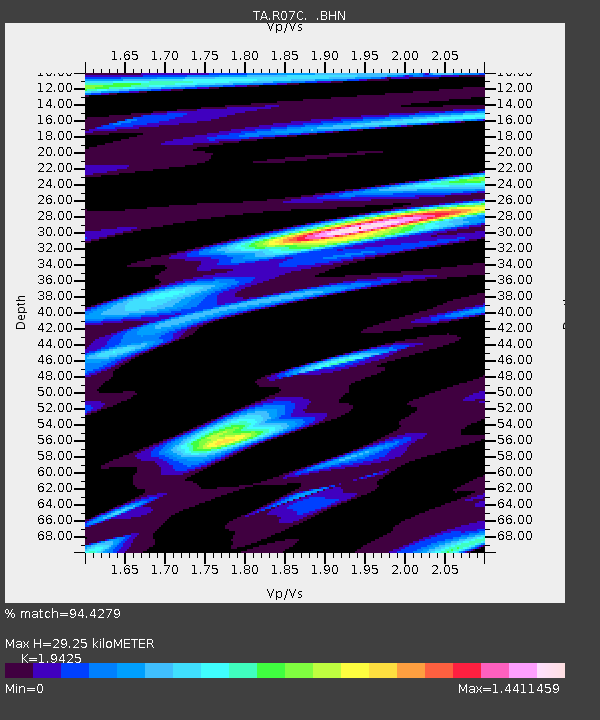
| Estimated Moho Depth: |
29.25 km |
| Estimated Crust Vp/Vs: |
1.94 |
| Assumed Crust Vp: |
6.279 km/s |
| Estimated Crust Vs: |
3.232 km/s |
| Estimated Crust Poisson's Ratio: |
0.32 |
|
| Radial Match: |
94.4279 % |
| Radial Bump: |
400 |
| Transverse Match: |
94.71574 % |
| Transverse Bump: |
400 |
| SOD ConfigId: |
2564 |
| Insert Time: |
2010-03-07 02:35:59.043 +0000 |
| GWidth: |
2.5 |
| Max Bumps: |
400 |
| Tol: |
0.001 |
|
Signal To Noise
| Channel | StoN | STA | LTA |
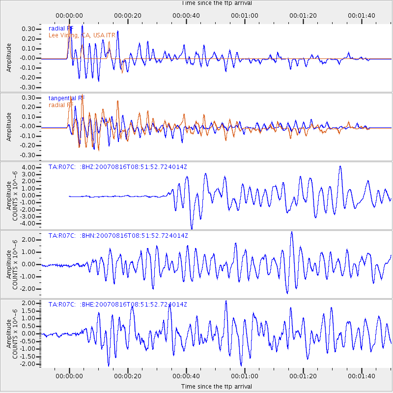
| TA:R07C: :BHN:20070816T08:51:52.724014Z | 1.0229657 | 8.557085E-8 | 8.364977E-8 |
| TA:R07C: :BHE:20070816T08:51:52.724014Z | 1.4700534 | 9.83276E-8 | 6.688708E-8 |
| TA:R07C: :BHZ:20070816T08:51:52.724014Z | 4.139472 | 2.1194636E-7 | 5.1201305E-8 |
| Arrivals |
| Ps | 4.5 SECOND |
| PpPs | 13 SECOND |
| PsPs/PpSs | 18 SECOND |


