You are here: Home > Network List > UW - Pacific Northwest Regional Seismic Network Stations List
> Station WOLL Wollman Farm, Schrag, WA, USA > Earthquake Result Viewer
WOLL Wollman Farm, Schrag, WA, USA - Earthquake Result Viewer
| Earthquake location: |
Vanuatu Islands |
| Earthquake latitude/longitude: |
-16.2/167.9 |
| Earthquake time(UTC): |
2019/07/31 (212) 15:02:33 GMT |
| Earthquake Depth: |
179 km |
| Earthquake Magnitude: |
6.6 mww |
| Earthquake Catalog/Contributor: |
NEIC PDE/us |
|
| Network: |
UW Pacific Northwest Regional Seismic Network |
| Station: |
WOLL Wollman Farm, Schrag, WA, USA |
| Lat/Lon: |
47.06 N/118.92 W |
| Elevation: |
385 m |
|
| Distance: |
90.6 deg |
| Az: |
40.87 deg |
| Baz: |
246.88 deg |
| Ray Param: |
0.04162005 |
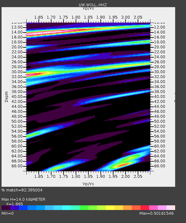
| Estimated Moho Depth: |
14.0 km |
| Estimated Crust Vp/Vs: |
1.66 |
| Assumed Crust Vp: |
6.419 km/s |
| Estimated Crust Vs: |
3.855 km/s |
| Estimated Crust Poisson's Ratio: |
0.22 |
|
| Radial Match: |
92.395004 % |
| Radial Bump: |
400 |
| Transverse Match: |
78.221565 % |
| Transverse Bump: |
400 |
| SOD ConfigId: |
19053131 |
| Insert Time: |
2019-08-14 15:12:34.078 +0000 |
| GWidth: |
2.5 |
| Max Bumps: |
400 |
| Tol: |
0.001 |
|
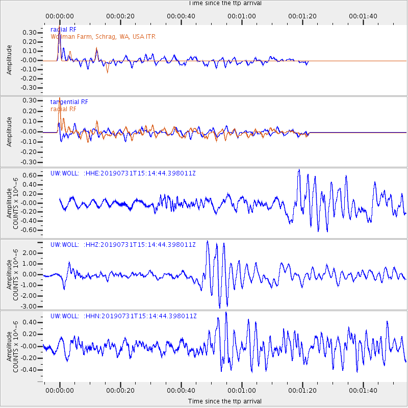
Signal To Noise
| Channel | StoN | STA | LTA |
| UW:WOLL: :HHZ:20190731T15:14:44.398011Z | 6.9496207 | 5.8962314E-7 | 8.484249E-8 |
| UW:WOLL: :HHN:20190731T15:14:44.398011Z | 1.4480208 | 1.2564355E-7 | 8.676916E-8 |
| UW:WOLL: :HHE:20190731T15:14:44.398011Z | 1.5305037 | 1.00216454E-7 | 6.547939E-8 |
| Arrivals |
| Ps | 1.5 SECOND |
| PpPs | 5.7 SECOND |
| PsPs/PpSs | 7.2 SECOND |


