You are here: Home > Network List > TS - TERRAscope (Southern California Seismic Network) Stations List
> Station ISA Isabella, California, USA > Earthquake Result Viewer
ISA Isabella, California, USA - Earthquake Result Viewer
| Earthquake location: |
Eastern New Guinea Reg., P.N.G. |
| Earthquake latitude/longitude: |
-6.1/147.6 |
| Earthquake time(UTC): |
1992/05/15 (136) 07:05:04 GMT |
| Earthquake Depth: |
50 km |
| Earthquake Magnitude: |
6.2 MB, 7.1 MS |
| Earthquake Catalog/Contributor: |
WHDF/NEIC |
|
| Network: |
TS TERRAscope (Southern California Seismic Network) |
| Station: |
ISA Isabella, California, USA |
| Lat/Lon: |
35.66 N/118.47 W |
| Elevation: |
835 m |
|
| Distance: |
96.7 deg |
| Az: |
54.881 deg |
| Baz: |
267.357 deg |
| Ray Param: |
0.040407244 |
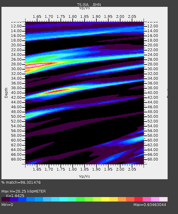
| Estimated Moho Depth: |
28.25 km |
| Estimated Crust Vp/Vs: |
1.64 |
| Assumed Crust Vp: |
6.1 km/s |
| Estimated Crust Vs: |
3.714 km/s |
| Estimated Crust Poisson's Ratio: |
0.21 |
|
| Radial Match: |
96.301476 % |
| Radial Bump: |
400 |
| Transverse Match: |
85.53303 % |
| Transverse Bump: |
400 |
| SOD ConfigId: |
16938 |
| Insert Time: |
2010-02-26 14:22:36.224 +0000 |
| GWidth: |
2.5 |
| Max Bumps: |
400 |
| Tol: |
0.001 |
|

Signal To Noise
| Channel | StoN | STA | LTA |
| TS:ISA: :BHN:19920515T07:17:58.194019Z | 0.77068925 | 7.959699E-8 | 1.0328026E-7 |
| TS:ISA: :BHE:19920515T07:17:58.194019Z | 0.8296547 | 8.892415E-8 | 1.07182125E-7 |
| TS:ISA: :BHZ:19920515T07:17:58.194019Z | 1.7102097 | 2.1755828E-7 | 1.2721146E-7 |
| Arrivals |
| Ps | 3.0 SECOND |
| PpPs | 12 SECOND |
| PsPs/PpSs | 15 SECOND |


