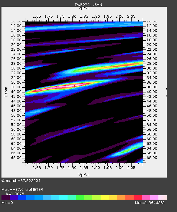
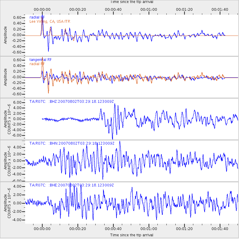
R07C Lee Vining, CA, USA - Earthquake Result Viewer

Earthquake location: Andreanof Islands, Aleutian Is.
Earthquake latitude/longitude: 51.3/-180.0
Earthquake time(UTC): 2007/08/02 (214) 03:21:42 GMT
Earthquake Depth: 21 km
Earthquake Magnitude: 6.3 MB, 6.6 MS, 6.7 MW, 6.6 MW
Earthquake Catalog/Contributor: WHDF/NEIC
Network: TA USArray Transportable Network (new EarthScope stations)
Station: R07C Lee Vining, CA, USA
Lat/Lon: 38.09 N/119.05 W
Elevation: 1996 m
Distance: 44.0 deg
Az: 82.801 deg
Baz: 307.886 deg
Ray Param: 0.07213595
Estimated Moho Depth: 37.0 km
Estimated Crust Vp/Vs: 1.81
Assumed Crust Vp: 6.279 km/s
Estimated Crust Vs: 3.474 km/s
Estimated Crust Poisson's Ratio: 0.28
Radial Match: 87.823204 %
Radial Bump: 400
Transverse Match: 82.30595 %
Transverse Bump: 400
SOD ConfigId: 2564
Insert Time: 2010-03-07 02:36:08.165 +0000
GWidth: 2.5
Max Bumps: 400
Tol: 0.001

Signal To Noise

ChannelStoNSTALTA
TA:R07C: :BHN:20070802T03:29:18.123009Z1.03507956.064647E-75.8591127E-7
TA:R07C: :BHE:20070802T03:29:18.123009Z0.974890535.1972773E-75.331139E-7
TA:R07C: :BHZ:20070802T03:29:18.123009Z4.8679611.5008695E-63.0831586E-7
Arrivals
Ps5.1 SECOND
PpPs16 SECOND
PsPs/PpSs21 SECOND