You are here: Home > Network List > AE - Arizona Broadband Seismic Network Stations List
> Station 113A Mohawk Valley, Roll, AZ, USA > Earthquake Result Viewer
113A Mohawk Valley, Roll, AZ, USA - Earthquake Result Viewer
| Earthquake location: |
Near Coast Of Central Chile |
| Earthquake latitude/longitude: |
-34.2/-72.3 |
| Earthquake time(UTC): |
2019/08/01 (213) 18:28:05 GMT |
| Earthquake Depth: |
10 km |
| Earthquake Magnitude: |
6.8 mww |
| Earthquake Catalog/Contributor: |
NEIC PDE/us |
|
| Network: |
AE Arizona Broadband Seismic Network |
| Station: |
113A Mohawk Valley, Roll, AZ, USA |
| Lat/Lon: |
32.77 N/113.77 W |
| Elevation: |
118 m |
|
| Distance: |
77.2 deg |
| Az: |
325.092 deg |
| Baz: |
145.757 deg |
| Ray Param: |
0.050469287 |
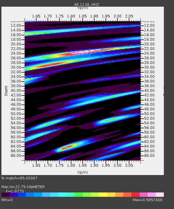
| Estimated Moho Depth: |
22.75 km |
| Estimated Crust Vp/Vs: |
1.88 |
| Assumed Crust Vp: |
6.264 km/s |
| Estimated Crust Vs: |
3.336 km/s |
| Estimated Crust Poisson's Ratio: |
0.30 |
|
| Radial Match: |
95.00087 % |
| Radial Bump: |
303 |
| Transverse Match: |
88.822525 % |
| Transverse Bump: |
363 |
| SOD ConfigId: |
19053131 |
| Insert Time: |
2019-08-15 18:29:47.875 +0000 |
| GWidth: |
2.5 |
| Max Bumps: |
400 |
| Tol: |
0.001 |
|

Signal To Noise
| Channel | StoN | STA | LTA |
| AE:113A: :HHZ:20190801T18:39:28.030005Z | 2.3345516 | 1.513151E-7 | 6.481549E-8 |
| AE:113A: :HHN:20190801T18:39:28.030005Z | 2.0334625 | 8.773358E-8 | 4.3144922E-8 |
| AE:113A: :HHE:20190801T18:39:28.030005Z | 1.107632 | 8.059157E-8 | 7.276024E-8 |
| Arrivals |
| Ps | 3.3 SECOND |
| PpPs | 10 SECOND |
| PsPs/PpSs | 13 SECOND |


