You are here: Home > Network List > TA - USArray Transportable Network (new EarthScope stations) Stations List
> Station R07C Lee Vining, CA, USA > Earthquake Result Viewer
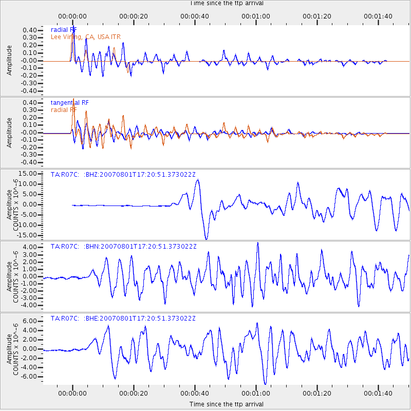
R07C Lee Vining, CA, USA - Earthquake Result Viewer
| Earthquake location: |
Vanuatu Islands |
| Earthquake latitude/longitude: |
-15.6/167.7 |
| Earthquake time(UTC): |
2007/08/01 (213) 17:08:51 GMT |
| Earthquake Depth: |
120 km |
| Earthquake Magnitude: |
6.2 MB, 7.2 MW, 7.2 MW |
| Earthquake Catalog/Contributor: |
WHDF/NEIC |
|
| Network: |
TA USArray Transportable Network (new EarthScope stations) |
| Station: |
R07C Lee Vining, CA, USA |
| Lat/Lon: |
38.09 N/119.05 W |
| Elevation: |
1996 m |
|
| Distance: |
86.9 deg |
| Az: |
49.183 deg |
| Baz: |
247.557 deg |
| Ray Param: |
0.043480147 |
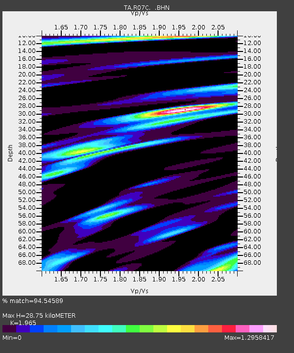
| Estimated Moho Depth: |
28.75 km |
| Estimated Crust Vp/Vs: |
1.97 |
| Assumed Crust Vp: |
6.279 km/s |
| Estimated Crust Vs: |
3.195 km/s |
| Estimated Crust Poisson's Ratio: |
0.33 |
|
| Radial Match: |
94.54589 % |
| Radial Bump: |
400 |
| Transverse Match: |
92.1879 % |
| Transverse Bump: |
400 |
| SOD ConfigId: |
2564 |
| Insert Time: |
2010-03-07 02:36:09.617 +0000 |
| GWidth: |
2.5 |
| Max Bumps: |
400 |
| Tol: |
0.001 |
|
Signal To Noise
| Channel | StoN | STA | LTA |
| TA:R07C: :BHN:20070801T17:20:51.373022Z | 0.9566079 | 8.1816424E-8 | 8.552765E-8 |
| TA:R07C: :BHE:20070801T17:20:51.373022Z | 1.2417498 | 1.5798881E-7 | 1.2723079E-7 |
| TA:R07C: :BHZ:20070801T17:20:51.373022Z | 4.6630893 | 6.212087E-7 | 1.3321828E-7 |
| Arrivals |
| Ps | 4.5 SECOND |
| PpPs | 13 SECOND |
| PsPs/PpSs | 18 SECOND |


