You are here: Home > Network List > TA - USArray Transportable Network (new EarthScope stations) Stations List
> Station R07C Lee Vining, CA, USA > Earthquake Result Viewer
R07C Lee Vining, CA, USA - Earthquake Result Viewer

| Earthquake location: |
Near Coast Of Guatemala |
| Earthquake latitude/longitude: |
13.8/-90.8 |
| Earthquake time(UTC): |
2007/06/08 (159) 13:32:00 GMT |
| Earthquake Depth: |
48 km |
| Earthquake Magnitude: |
5.5 MB, 5.4 MS, 5.8 MW, 5.8 MW |
| Earthquake Catalog/Contributor: |
WHDF/NEIC |
|
| Network: |
TA USArray Transportable Network (new EarthScope stations) |
| Station: |
R07C Lee Vining, CA, USA |
| Lat/Lon: |
38.09 N/119.05 W |
| Elevation: |
1996 m |
|
| Distance: |
34.8 deg |
| Az: |
319.101 deg |
| Baz: |
126.295 deg |
| Ray Param: |
0.077431135 |
| Estimated Moho Depth: |
28.0 km |
| Estimated Crust Vp/Vs: |
1.92 |
| Assumed Crust Vp: |
6.279 km/s |
| Estimated Crust Vs: |
3.266 km/s |
| Estimated Crust Poisson's Ratio: |
0.31 |
|
| Radial Match: |
87.125984 % |
| Radial Bump: |
400 |
| Transverse Match: |
72.00505 % |
| Transverse Bump: |
400 |
| SOD ConfigId: |
2564 |
| Insert Time: |
2010-03-07 02:36:23.063 +0000 |
| GWidth: |
2.5 |
| Max Bumps: |
400 |
| Tol: |
0.001 |
|
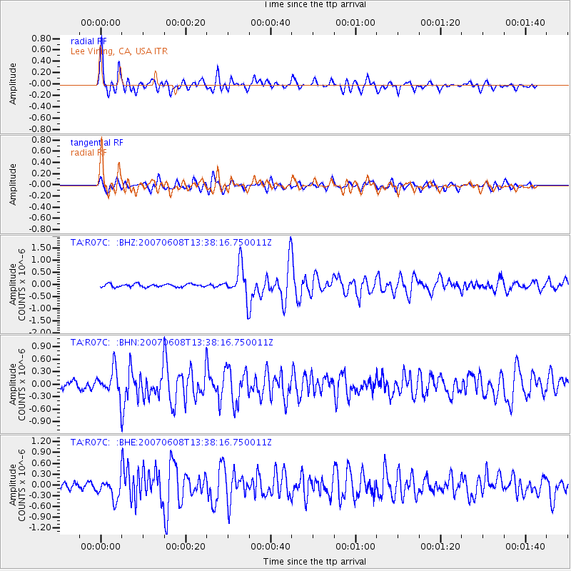
Signal To Noise
| Channel | StoN | STA | LTA |
| TA:R07C: :BHN:20070608T13:38:16.750011Z | 5.108266 | 3.4372306E-7 | 6.728762E-8 |
| TA:R07C: :BHE:20070608T13:38:16.750011Z | 2.89408 | 2.9997344E-7 | 1.03650706E-7 |
| TA:R07C: :BHZ:20070608T13:38:16.750011Z | 11.1365185 | 6.811748E-7 | 6.116587E-8 |
| Arrivals |
| Ps | 4.4 SECOND |
| PpPs | 12 SECOND |
| PsPs/PpSs | 17 SECOND |


