You are here: Home > Network List > TA - USArray Transportable Network (new EarthScope stations) Stations List
> Station R07C Lee Vining, CA, USA > Earthquake Result Viewer
R07C Lee Vining, CA, USA - Earthquake Result Viewer
| Earthquake location: |
Solomon Islands |
| Earthquake latitude/longitude: |
-7.3/155.4 |
| Earthquake time(UTC): |
2007/04/01 (091) 21:26:26 GMT |
| Earthquake Depth: |
10 km |
| Earthquake Magnitude: |
5.6 MB |
| Earthquake Catalog/Contributor: |
WHDF/NEIC |
|
| Network: |
TA USArray Transportable Network (new EarthScope stations) |
| Station: |
R07C Lee Vining, CA, USA |
| Lat/Lon: |
38.09 N/119.05 W |
| Elevation: |
1996 m |
|
| Distance: |
90.9 deg |
| Az: |
51.886 deg |
| Baz: |
261.576 deg |
| Ray Param: |
0.04163777 |
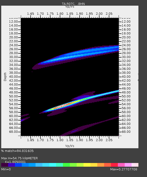
| Estimated Moho Depth: |
54.75 km |
| Estimated Crust Vp/Vs: |
1.81 |
| Assumed Crust Vp: |
6.279 km/s |
| Estimated Crust Vs: |
3.478 km/s |
| Estimated Crust Poisson's Ratio: |
0.28 |
|
| Radial Match: |
94.831635 % |
| Radial Bump: |
304 |
| Transverse Match: |
94.599815 % |
| Transverse Bump: |
171 |
| SOD ConfigId: |
2564 |
| Insert Time: |
2010-03-07 02:36:28.398 +0000 |
| GWidth: |
2.5 |
| Max Bumps: |
400 |
| Tol: |
0.001 |
|

Signal To Noise
| Channel | StoN | STA | LTA |
| TA:R07C: :BHN:20070401T21:38:58.848022Z | 2.1980119 | 2.2525557E-5 | 1.0248151E-5 |
| TA:R07C: :BHE:20070401T21:38:58.848022Z | 0.8009694 | 2.9648665E-5 | 3.7015976E-5 |
| TA:R07C: :BHZ:20070401T21:38:58.848022Z | 0.56321913 | 3.0587395E-5 | 5.4308155E-5 |
| Arrivals |
| Ps | 7.2 SECOND |
| PpPs | 24 SECOND |
| PsPs/PpSs | 31 SECOND |


