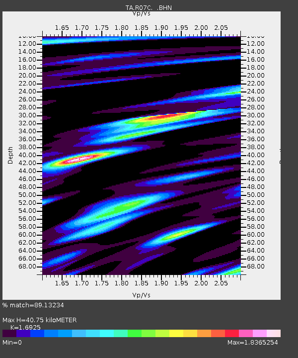
R07C Lee Vining, CA, USA - Earthquake Result Viewer
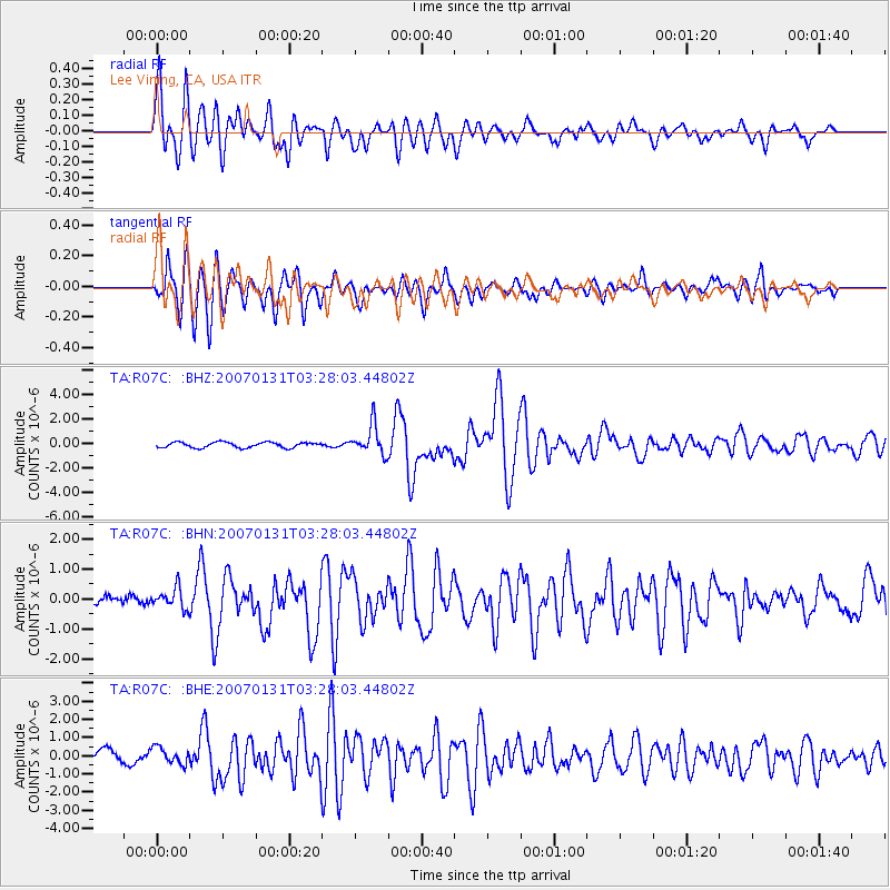
Earthquake location: Kermadec Islands, New Zealand
Earthquake latitude/longitude: -29.8/-178.0
Earthquake time(UTC): 2007/01/31 (031) 03:15:52 GMT
Earthquake Depth: 34 km
Earthquake Magnitude: 6.1 MB, 6.3 MS, 6.5 MW, 6.4 MW
Earthquake Catalog/Contributor: WHDF/NEIC
Network: TA USArray Transportable Network (new EarthScope stations)
Station: R07C Lee Vining, CA, USA
Lat/Lon: 38.09 N/119.05 W
Elevation: 1996 m
Distance: 87.1 deg
Az: 42.601 deg
Baz: 228.229 deg
Ray Param: 0.043508835
Estimated Moho Depth: 40.75 km
Estimated Crust Vp/Vs: 1.69
Assumed Crust Vp: 6.279 km/s
Estimated Crust Vs: 3.71 km/s
Estimated Crust Poisson's Ratio: 0.23
Radial Match: 89.13234 %
Radial Bump: 400
Transverse Match: 87.28038 %
Transverse Bump: 400
SOD ConfigId: 2564
Insert Time: 2010-03-07 02:36:31.422 +0000
GWidth: 2.5
Max Bumps: 400
Tol: 0.001

Signal To Noise

ChannelStoNSTALTA
TA:R07C: :BHN:20070131T03:28:03.44802Z1.7644453.5965715E-72.0383585E-7
TA:R07C: :BHE:20070131T03:28:03.44802Z1.2689124.6222263E-73.642669E-7
TA:R07C: :BHZ:20070131T03:28:03.44802Z5.3607111.181907E-62.204758E-7
Arrivals
Ps4.6 SECOND
PpPs17 SECOND
PsPs/PpSs22 SECOND