You are here: Home > Network List > TA - USArray Transportable Network (new EarthScope stations) Stations List
> Station R07C Lee Vining, CA, USA > Earthquake Result Viewer
R07C Lee Vining, CA, USA - Earthquake Result Viewer
| Earthquake location: |
Kamchatka Peninsula, Russia |
| Earthquake latitude/longitude: |
54.3/158.4 |
| Earthquake time(UTC): |
2006/05/22 (142) 13:08:01 GMT |
| Earthquake Depth: |
185 km |
| Earthquake Magnitude: |
6.2 MB, 6.2 MW, 6.2 MW |
| Earthquake Catalog/Contributor: |
WHDF/NEIC |
|
| Network: |
TA USArray Transportable Network (new EarthScope stations) |
| Station: |
R07C Lee Vining, CA, USA |
| Lat/Lon: |
38.09 N/119.05 W |
| Elevation: |
1996 m |
|
| Distance: |
56.1 deg |
| Az: |
70.496 deg |
| Baz: |
315.528 deg |
| Ray Param: |
0.06374804 |
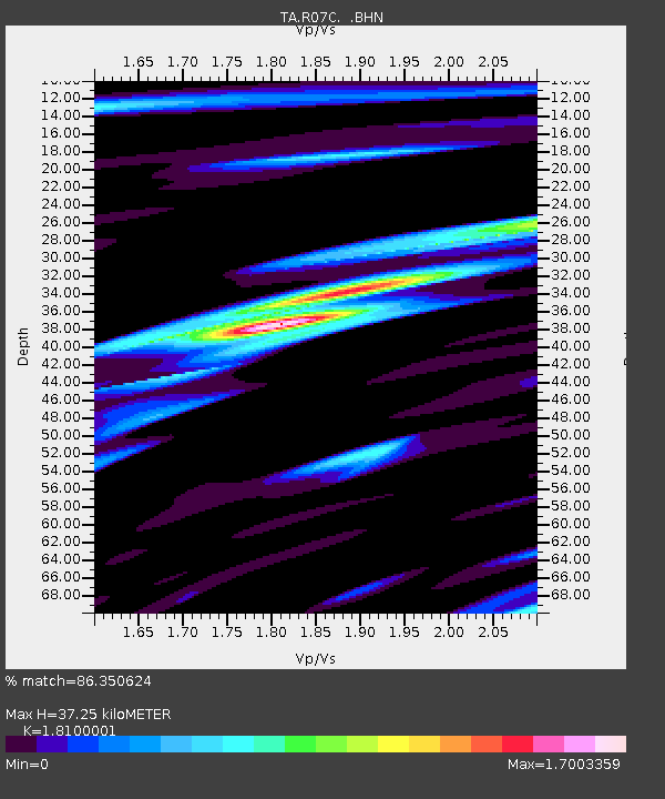
| Estimated Moho Depth: |
37.25 km |
| Estimated Crust Vp/Vs: |
1.81 |
| Assumed Crust Vp: |
6.279 km/s |
| Estimated Crust Vs: |
3.469 km/s |
| Estimated Crust Poisson's Ratio: |
0.28 |
|
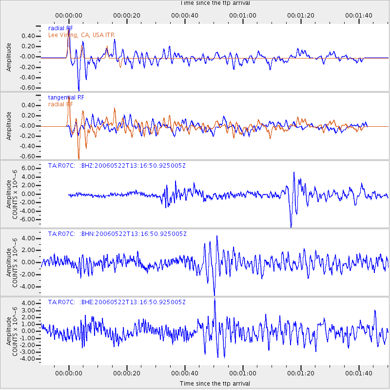
| Radial Match: |
86.350624 % |
| Radial Bump: |
400 |
| Transverse Match: |
71.34443 % |
| Transverse Bump: |
400 |
| SOD ConfigId: |
2669 |
| Insert Time: |
2010-03-07 02:37:10.213 +0000 |
| GWidth: |
2.5 |
| Max Bumps: |
400 |
| Tol: |
0.001 |
|
Signal To Noise
| Channel | StoN | STA | LTA |
| TA:R07C: :BHN:20060522T13:16:50.925005Z | 1.6698561 | 8.568714E-7 | 5.131409E-7 |
| TA:R07C: :BHE:20060522T13:16:50.925005Z | 1.4090815 | 8.996666E-7 | 6.3847733E-7 |
| TA:R07C: :BHZ:20060522T13:16:50.925005Z | 4.1862574 | 1.2822449E-6 | 3.0629863E-7 |
| Arrivals |
| Ps | 5.0 SECOND |
| PpPs | 16 SECOND |
| PsPs/PpSs | 21 SECOND |


