You are here: Home > Network List > TA - USArray Transportable Network (new EarthScope stations) Stations List
> Station R07C Lee Vining, CA, USA > Earthquake Result Viewer
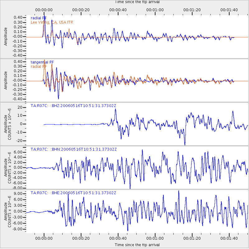
R07C Lee Vining, CA, USA - Earthquake Result Viewer

| Earthquake location: |
Kermadec Islands Region |
| Earthquake latitude/longitude: |
-31.8/-179.3 |
| Earthquake time(UTC): |
2006/05/16 (136) 10:39:23 GMT |
| Earthquake Depth: |
152 km |
| Earthquake Magnitude: |
6.8 MB, 7.4 MW, 7.4 MW |
| Earthquake Catalog/Contributor: |
WHDF/NEIC |
|
| Network: |
TA USArray Transportable Network (new EarthScope stations) |
| Station: |
R07C Lee Vining, CA, USA |
| Lat/Lon: |
38.09 N/119.05 W |
| Elevation: |
1996 m |
|
| Distance: |
89.4 deg |
| Az: |
43.252 deg |
| Baz: |
227.696 deg |
| Ray Param: |
0.04171907 |
| Estimated Moho Depth: |
32.0 km |
| Estimated Crust Vp/Vs: |
1.84 |
| Assumed Crust Vp: |
6.279 km/s |
| Estimated Crust Vs: |
3.417 km/s |
| Estimated Crust Poisson's Ratio: |
0.29 |
|
| Radial Match: |
90.90233 % |
| Radial Bump: |
400 |
| Transverse Match: |
89.24446 % |
| Transverse Bump: |
400 |
| SOD ConfigId: |
2669 |
| Insert Time: |
2010-03-07 02:37:12.947 +0000 |
| GWidth: |
2.5 |
| Max Bumps: |
400 |
| Tol: |
0.001 |
|
Signal To Noise
| Channel | StoN | STA | LTA |
| TA:R07C: :BHN:20060516T10:51:31.37302Z | 1.1839957 | 1.327658E-7 | 1.1213368E-7 |
| TA:R07C: :BHE:20060516T10:51:31.37302Z | 1.5698656 | 3.0506027E-7 | 1.9432254E-7 |
| TA:R07C: :BHZ:20060516T10:51:31.37302Z | 5.6406 | 7.312011E-7 | 1.2963179E-7 |
| Arrivals |
| Ps | 4.4 SECOND |
| PpPs | 14 SECOND |
| PsPs/PpSs | 19 SECOND |


