You are here: Home > Network List > TA - USArray Transportable Network (new EarthScope stations) Stations List
> Station R07C Lee Vining, CA, USA > Earthquake Result Viewer
R07C Lee Vining, CA, USA - Earthquake Result Viewer

| Earthquake location: |
Fiji Islands Region |
| Earthquake latitude/longitude: |
-17.7/-178.4 |
| Earthquake time(UTC): |
2006/02/02 (033) 12:48:43 GMT |
| Earthquake Depth: |
598 km |
| Earthquake Magnitude: |
5.9 MB, 6.7 MW, 6.7 MW |
| Earthquake Catalog/Contributor: |
WHDF/NEIC |
|
| Network: |
TA USArray Transportable Network (new EarthScope stations) |
| Station: |
R07C Lee Vining, CA, USA |
| Lat/Lon: |
38.09 N/119.05 W |
| Elevation: |
1996 m |
|
| Distance: |
78.6 deg |
| Az: |
43.82 deg |
| Baz: |
236.746 deg |
| Ray Param: |
0.047647797 |
| Estimated Moho Depth: |
31.25 km |
| Estimated Crust Vp/Vs: |
1.82 |
| Assumed Crust Vp: |
6.279 km/s |
| Estimated Crust Vs: |
3.45 km/s |
| Estimated Crust Poisson's Ratio: |
0.28 |
|
| Radial Match: |
88.933685 % |
| Radial Bump: |
400 |
| Transverse Match: |
83.97137 % |
| Transverse Bump: |
400 |
| SOD ConfigId: |
4977 |
| Insert Time: |
2010-03-07 02:37:32.957 +0000 |
| GWidth: |
2.5 |
| Max Bumps: |
400 |
| Tol: |
0.001 |
|
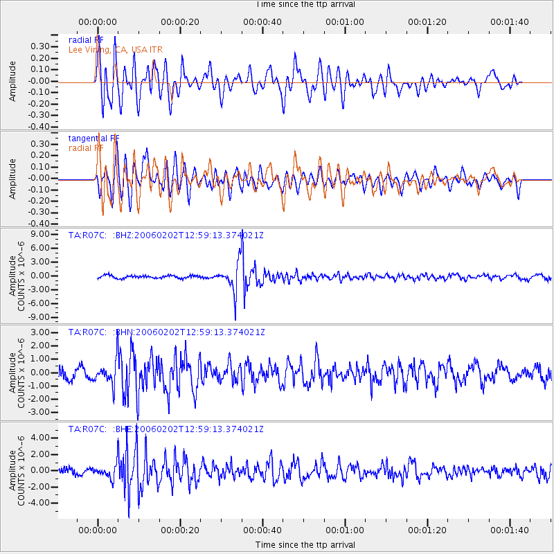
Signal To Noise
| Channel | StoN | STA | LTA |
| TA:R07C: :BHN:20060202T12:59:13.374021Z | 2.6538725 | 9.381988E-7 | 3.5352068E-7 |
| TA:R07C: :BHE:20060202T12:59:13.374021Z | 2.2423596 | 8.955702E-7 | 3.9938743E-7 |
| TA:R07C: :BHZ:20060202T12:59:13.374021Z | 10.5079775 | 3.1750608E-6 | 3.021572E-7 |
| Arrivals |
| Ps | 4.2 SECOND |
| PpPs | 14 SECOND |
| PsPs/PpSs | 18 SECOND |


