You are here: Home > Network List > N4 - Central and EAstern US Network Stations List
> Station G62A West of Eustis, ME, USA > Earthquake Result Viewer
G62A West of Eustis, ME, USA - Earthquake Result Viewer
| Earthquake location: |
Near Coast Of Central Chile |
| Earthquake latitude/longitude: |
-34.2/-72.3 |
| Earthquake time(UTC): |
2019/08/01 (213) 18:28:05 GMT |
| Earthquake Depth: |
10 km |
| Earthquake Magnitude: |
6.8 mww |
| Earthquake Catalog/Contributor: |
NEIC PDE/us |
|
| Network: |
N4 Central and EAstern US Network |
| Station: |
G62A West of Eustis, ME, USA |
| Lat/Lon: |
45.22 N/70.53 W |
| Elevation: |
426 m |
|
| Distance: |
79.1 deg |
| Az: |
1.26 deg |
| Baz: |
181.477 deg |
| Ray Param: |
0.049190506 |
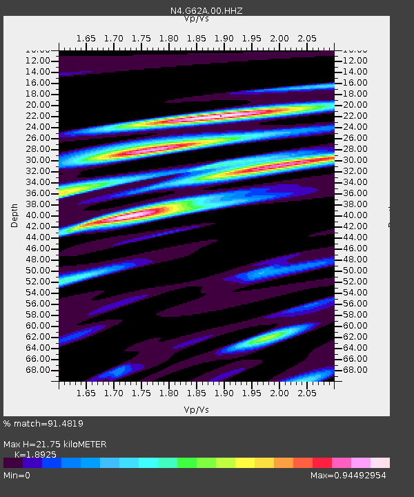
| Estimated Moho Depth: |
21.75 km |
| Estimated Crust Vp/Vs: |
1.89 |
| Assumed Crust Vp: |
6.419 km/s |
| Estimated Crust Vs: |
3.392 km/s |
| Estimated Crust Poisson's Ratio: |
0.31 |
|
| Radial Match: |
91.4819 % |
| Radial Bump: |
400 |
| Transverse Match: |
89.653595 % |
| Transverse Bump: |
400 |
| SOD ConfigId: |
19053131 |
| Insert Time: |
2019-08-15 18:33:33.199 +0000 |
| GWidth: |
2.5 |
| Max Bumps: |
400 |
| Tol: |
0.001 |
|

Signal To Noise
| Channel | StoN | STA | LTA |
| N4:G62A:00:HHZ:20190801T18:39:38.428992Z | 9.787777 | 1.2625586E-6 | 1.289934E-7 |
| N4:G62A:00:HH1:20190801T18:39:38.428992Z | 3.2538142 | 4.5992692E-7 | 1.4135009E-7 |
| N4:G62A:00:HH2:20190801T18:39:38.428992Z | 1.4575346 | 1.1985382E-7 | 8.223052E-8 |
| Arrivals |
| Ps | 3.1 SECOND |
| PpPs | 9.5 SECOND |
| PsPs/PpSs | 13 SECOND |


