You are here: Home > Network List > GS - US Geological Survey Networks Stations List
> Station OK048 Pawnee, OK, Station 48 > Earthquake Result Viewer
OK048 Pawnee, OK, Station 48 - Earthquake Result Viewer
| Earthquake location: |
Southern Chile |
| Earthquake latitude/longitude: |
-43.3/-74.5 |
| Earthquake time(UTC): |
2016/12/25 (360) 14:22:28 GMT |
| Earthquake Depth: |
15 km |
| Earthquake Magnitude: |
7.7 Mi |
| Earthquake Catalog/Contributor: |
NEIC PDE/at |
|
| Network: |
GS US Geological Survey Networks |
| Station: |
OK048 Pawnee, OK, Station 48 |
| Lat/Lon: |
36.42 N/96.94 W |
| Elevation: |
297 m |
|
| Distance: |
81.9 deg |
| Az: |
341.879 deg |
| Baz: |
163.65 deg |
| Ray Param: |
0.047231164 |
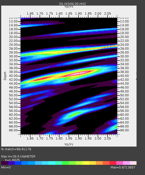
| Estimated Moho Depth: |
38.5 km |
| Estimated Crust Vp/Vs: |
1.90 |
| Assumed Crust Vp: |
6.483 km/s |
| Estimated Crust Vs: |
3.407 km/s |
| Estimated Crust Poisson's Ratio: |
0.31 |
|
| Radial Match: |
96.91176 % |
| Radial Bump: |
400 |
| Transverse Match: |
93.34075 % |
| Transverse Bump: |
400 |
| SOD ConfigId: |
1894071 |
| Insert Time: |
2017-01-08 14:29:12.182 +0000 |
| GWidth: |
2.5 |
| Max Bumps: |
400 |
| Tol: |
0.001 |
|

Signal To Noise
| Channel | StoN | STA | LTA |
| GS:OK048:00:HHZ:20161225T14:34:15.439026Z | 88.290764 | 1.2736893E-5 | 1.4426077E-7 |
| GS:OK048:00:HH1:20161225T14:34:15.439026Z | 26.82118 | 5.04094E-6 | 1.8794624E-7 |
| GS:OK048:00:HH2:20161225T14:34:15.439026Z | 8.836423 | 2.2160095E-6 | 2.5078128E-7 |
| Arrivals |
| Ps | 5.5 SECOND |
| PpPs | 17 SECOND |
| PsPs/PpSs | 22 SECOND |


