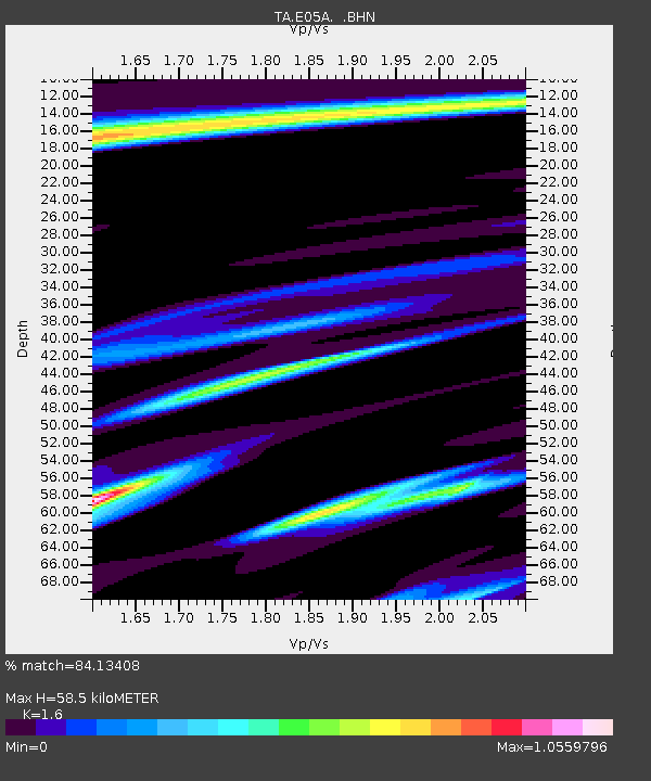
E05A Randle, WA, USA - Earthquake Result Viewer
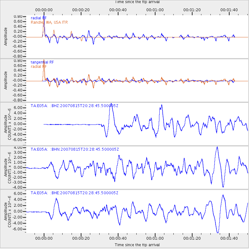
Earthquake location: Andreanof Islands, Aleutian Is.
Earthquake latitude/longitude: 50.3/-177.5
Earthquake time(UTC): 2007/08/15 (227) 20:22:11 GMT
Earthquake Depth: 9.0 km
Earthquake Magnitude: 6.3 MB, 6.2 MS, 6.4 MW, 5.9 ML
Earthquake Catalog/Contributor: WHDF/NEIC
Network: TA USArray Transportable Network (new EarthScope stations)
Station: E05A Randle, WA, USA
Lat/Lon: 46.56 N/121.76 W
Elevation: 451 m
Distance: 36.5 deg
Az: 73.763 deg
Baz: 296.884 deg
Ray Param: 0.076668575
Estimated Moho Depth: 58.5 km
Estimated Crust Vp/Vs: 1.60
Assumed Crust Vp: 6.597 km/s
Estimated Crust Vs: 4.123 km/s
Estimated Crust Poisson's Ratio: 0.18
Radial Match: 84.13408 %
Radial Bump: 359
Transverse Match: 51.45776 %
Transverse Bump: 400
SOD ConfigId: 2564
Insert Time: 2010-03-07 02:38:08.327 +0000
GWidth: 2.5
Max Bumps: 400
Tol: 0.001

Signal To Noise

ChannelStoNSTALTA
TA:E05A: :BHN:20070815T20:28:45.500005Z11.3869455.101839E-74.480428E-8
TA:E05A: :BHE:20070815T20:28:45.500005Z24.363621.0731062E-64.4045432E-8
TA:E05A: :BHZ:20070815T20:28:45.500005Z42.39572.0425914E-64.817921E-8
Arrivals
Ps5.8 SECOND
PpPs21 SECOND
PsPs/PpSs27 SECOND