You are here: Home > Network List > TA - USArray Transportable Network (new EarthScope stations) Stations List
> Station E05A Randle, WA, USA > Earthquake Result Viewer
E05A Randle, WA, USA - Earthquake Result Viewer
| Earthquake location: |
Vanuatu Islands |
| Earthquake latitude/longitude: |
-15.4/168.6 |
| Earthquake time(UTC): |
2007/07/15 (196) 09:27:34 GMT |
| Earthquake Depth: |
8.0 km |
| Earthquake Magnitude: |
6.0 MB, 5.8 MS, 6.1 MW, 6.0 MW |
| Earthquake Catalog/Contributor: |
WHDF/NEIC |
|
| Network: |
TA USArray Transportable Network (new EarthScope stations) |
| Station: |
E05A Randle, WA, USA |
| Lat/Lon: |
46.56 N/121.76 W |
| Elevation: |
451 m |
|
| Distance: |
87.7 deg |
| Az: |
40.35 deg |
| Baz: |
244.841 deg |
| Ray Param: |
0.043164648 |
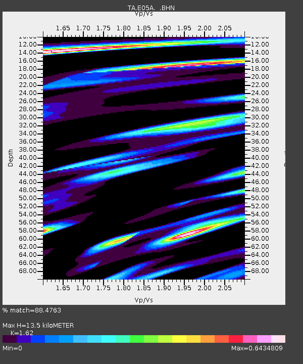
| Estimated Moho Depth: |
13.5 km |
| Estimated Crust Vp/Vs: |
1.62 |
| Assumed Crust Vp: |
6.597 km/s |
| Estimated Crust Vs: |
4.073 km/s |
| Estimated Crust Poisson's Ratio: |
0.19 |
|
| Radial Match: |
88.4763 % |
| Radial Bump: |
400 |
| Transverse Match: |
80.289116 % |
| Transverse Bump: |
400 |
| SOD ConfigId: |
2564 |
| Insert Time: |
2010-03-07 02:38:14.875 +0000 |
| GWidth: |
2.5 |
| Max Bumps: |
400 |
| Tol: |
0.001 |
|
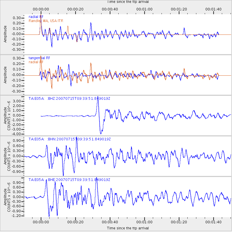
Signal To Noise
| Channel | StoN | STA | LTA |
| TA:E05A: :BHN:20070715T09:39:51.849019Z | 9.242613 | 2.8575892E-7 | 3.0917544E-8 |
| TA:E05A: :BHE:20070715T09:39:51.849019Z | 12.259994 | 5.3277904E-7 | 4.3456716E-8 |
| TA:E05A: :BHZ:20070715T09:39:51.849019Z | 43.314137 | 1.9562572E-6 | 4.5164402E-8 |
| Arrivals |
| Ps | 1.3 SECOND |
| PpPs | 5.2 SECOND |
| PsPs/PpSs | 6.5 SECOND |


