You are here: Home > Network List > TA - USArray Transportable Network (new EarthScope stations) Stations List
> Station E05A Randle, WA, USA > Earthquake Result Viewer
E05A Randle, WA, USA - Earthquake Result Viewer
| Earthquake location: |
Gulf Of Mexico |
| Earthquake latitude/longitude: |
21.9/-96.4 |
| Earthquake time(UTC): |
2007/05/23 (143) 19:09:15 GMT |
| Earthquake Depth: |
10 km |
| Earthquake Magnitude: |
5.6 MW, 4.8 MS, 5.4 MB |
| Earthquake Catalog/Contributor: |
WHDF/NEIC |
|
| Network: |
TA USArray Transportable Network (new EarthScope stations) |
| Station: |
E05A Randle, WA, USA |
| Lat/Lon: |
46.56 N/121.76 W |
| Elevation: |
451 m |
|
| Distance: |
32.1 deg |
| Az: |
326.141 deg |
| Baz: |
131.417 deg |
| Ray Param: |
0.078799814 |
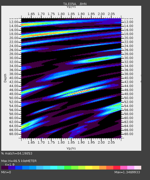
| Estimated Moho Depth: |
46.5 km |
| Estimated Crust Vp/Vs: |
1.90 |
| Assumed Crust Vp: |
6.597 km/s |
| Estimated Crust Vs: |
3.472 km/s |
| Estimated Crust Poisson's Ratio: |
0.31 |
|
| Radial Match: |
84.19853 % |
| Radial Bump: |
400 |
| Transverse Match: |
71.01411 % |
| Transverse Bump: |
400 |
| SOD ConfigId: |
2564 |
| Insert Time: |
2010-03-07 02:38:22.380 +0000 |
| GWidth: |
2.5 |
| Max Bumps: |
400 |
| Tol: |
0.001 |
|
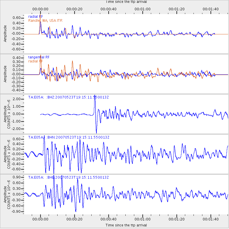
Signal To Noise
| Channel | StoN | STA | LTA |
| TA:E05A: :BHN:20070523T19:15:11.550013Z | 7.278743 | 3.3083867E-7 | 4.5452722E-8 |
| TA:E05A: :BHE:20070523T19:15:11.550013Z | 3.9424098 | 2.3999243E-7 | 6.0874555E-8 |
| TA:E05A: :BHZ:20070523T19:15:11.550013Z | 18.943966 | 1.0970332E-6 | 5.7909375E-8 |
| Arrivals |
| Ps | 6.9 SECOND |
| PpPs | 19 SECOND |
| PsPs/PpSs | 26 SECOND |


