You are here: Home > Network List > TA - USArray Transportable Network (new EarthScope stations) Stations List
> Station E05A Randle, WA, USA > Earthquake Result Viewer
E05A Randle, WA, USA - Earthquake Result Viewer
| Earthquake location: |
Kuril Islands |
| Earthquake latitude/longitude: |
46.6/153.3 |
| Earthquake time(UTC): |
2006/11/15 (319) 11:14:13 GMT |
| Earthquake Depth: |
10 km |
| Earthquake Magnitude: |
6.5 MB, 7.8 MS, 8.3 MW, 7.9 MW |
| Earthquake Catalog/Contributor: |
WHDF/NEIC |
|
| Network: |
TA USArray Transportable Network (new EarthScope stations) |
| Station: |
E05A Randle, WA, USA |
| Lat/Lon: |
46.56 N/121.76 W |
| Elevation: |
451 m |
|
| Distance: |
55.5 deg |
| Az: |
56.476 deg |
| Baz: |
303.573 deg |
| Ray Param: |
0.06472701 |
| Estimated Moho Depth: |
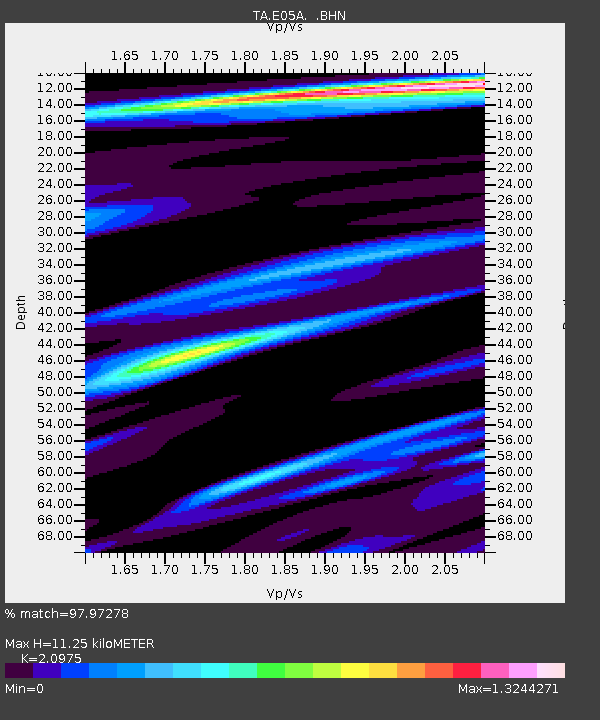
11.25 km |
| Estimated Crust Vp/Vs: |
2.10 |
| Assumed Crust Vp: |
6.597 km/s |
| Estimated Crust Vs: |
3.145 km/s |
| Estimated Crust Poisson's Ratio: |
0.35 |
|
| Radial Match: |
97.97278 % |
| Radial Bump: |
394 |
| Transverse Match: |
91.15437 % |
| Transverse Bump: |
400 |
| SOD ConfigId: |
2564 |
| Insert Time: |
2010-03-07 02:38:31.847 +0000 |
| GWidth: |
2.5 |
| Max Bumps: |
400 |
| Tol: |
0.001 |
|
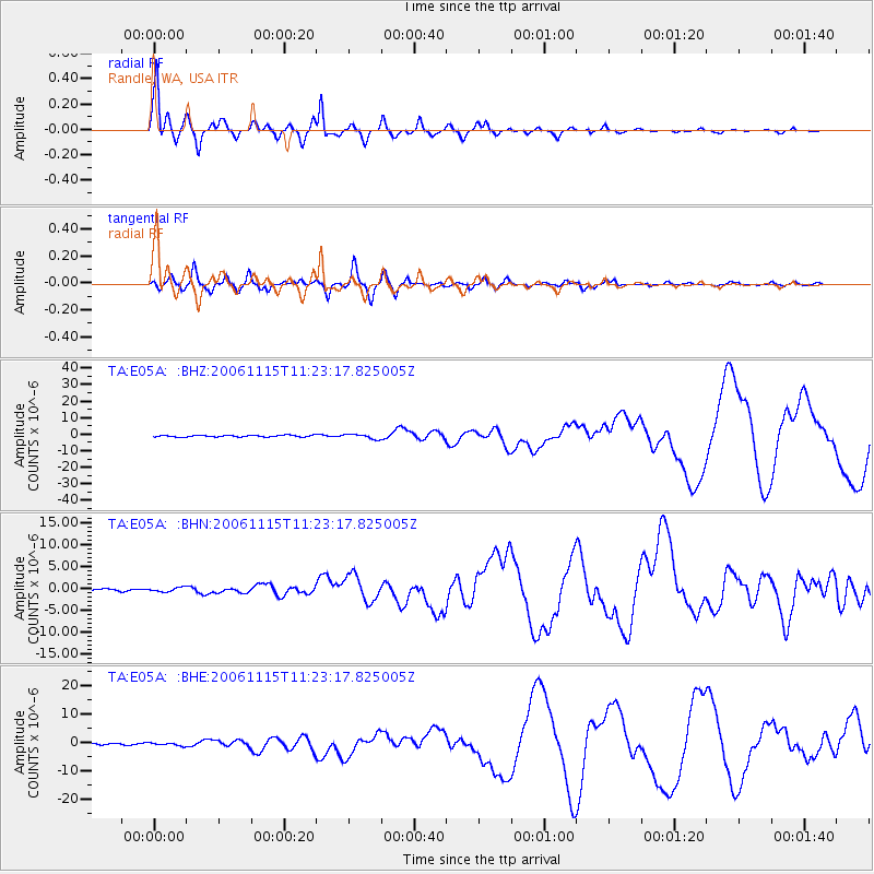
Signal To Noise
| Channel | StoN | STA | LTA |
| TA:E05A: :BHN:20061115T11:23:17.825005Z | 1.2279427 | 4.5877889E-7 | 3.7361588E-7 |
| TA:E05A: :BHE:20061115T11:23:17.825005Z | 1.3583398 | 4.710893E-7 | 3.4681256E-7 |
| TA:E05A: :BHZ:20061115T11:23:17.825005Z | 3.1854625 | 1.4924402E-6 | 4.6851602E-7 |
| Arrivals |
| Ps | 2.0 SECOND |
| PpPs | 5.0 SECOND |
| PsPs/PpSs | 7.0 SECOND |


