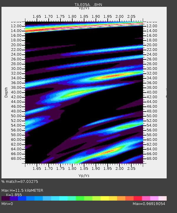
E05A Randle, WA, USA - Earthquake Result Viewer
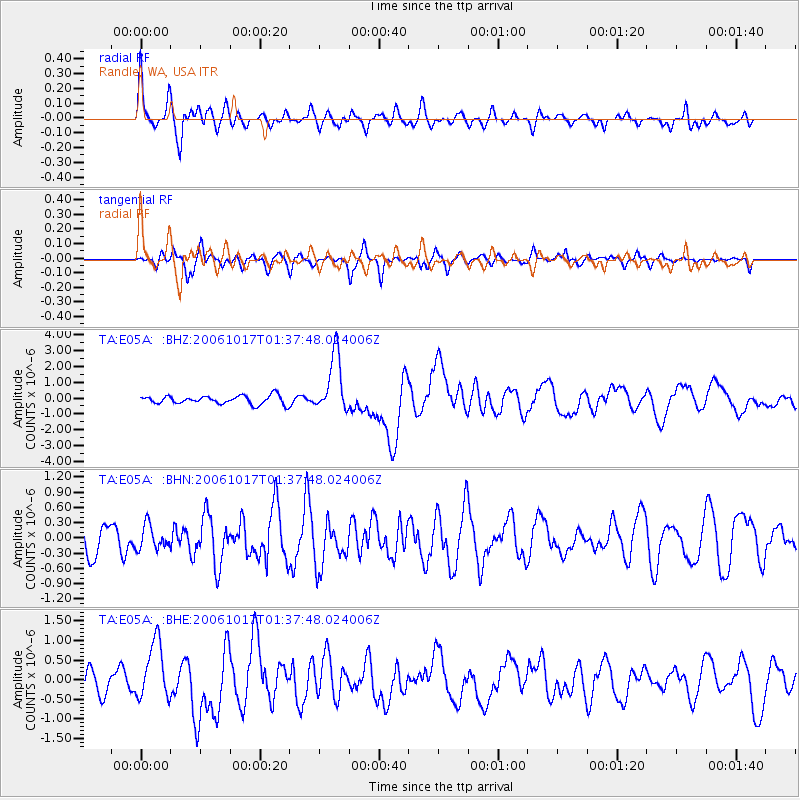
Earthquake location: New Britain Region, P.N.G.
Earthquake latitude/longitude: -5.9/151.0
Earthquake time(UTC): 2006/10/17 (290) 01:25:12 GMT
Earthquake Depth: 32 km
Earthquake Magnitude: 6.4 MB, 6.9 MS, 6.7 MW, 6.6 MW
Earthquake Catalog/Contributor: WHDF/NEIC
Network: TA USArray Transportable Network (new EarthScope stations)
Station: E05A Randle, WA, USA
Lat/Lon: 46.56 N/121.76 W
Elevation: 451 m
Distance: 92.3 deg
Az: 43.615 deg
Baz: 263.986 deg
Ray Param: 0.041464984
Estimated Moho Depth: 11.5 km
Estimated Crust Vp/Vs: 1.96
Assumed Crust Vp: 6.597 km/s
Estimated Crust Vs: 3.375 km/s
Estimated Crust Poisson's Ratio: 0.32
Radial Match: 87.03275 %
Radial Bump: 400
Transverse Match: 75.57955 %
Transverse Bump: 400
SOD ConfigId: 2564
Insert Time: 2010-03-07 02:38:34.476 +0000
GWidth: 2.5
Max Bumps: 400
Tol: 0.001

Signal To Noise

ChannelStoNSTALTA
TA:E05A: :BHN:20061017T01:37:48.024006Z0.85735222.3459015E-72.7362168E-7
TA:E05A: :BHE:20061017T01:37:48.024006Z3.76496987.290485E-71.9363993E-7
TA:E05A: :BHZ:20061017T01:37:48.024006Z6.95748041.8298493E-62.6300458E-7
Arrivals
Ps1.7 SECOND
PpPs5.1 SECOND
PsPs/PpSs6.7 SECOND