You are here: Home > Network List > TA - USArray Transportable Network (new EarthScope stations) Stations List
> Station E05A Randle, WA, USA > Earthquake Result Viewer
E05A Randle, WA, USA - Earthquake Result Viewer
| Earthquake location: |
Kuril Islands |
| Earthquake latitude/longitude: |
46.5/153.2 |
| Earthquake time(UTC): |
2006/10/01 (274) 09:06:02 GMT |
| Earthquake Depth: |
19 km |
| Earthquake Magnitude: |
6.1 MB, 6.4 MS, 6.6 MW, 6.5 MW |
| Earthquake Catalog/Contributor: |
WHDF/NEIC |
|
| Network: |
TA USArray Transportable Network (new EarthScope stations) |
| Station: |
E05A Randle, WA, USA |
| Lat/Lon: |
46.56 N/121.76 W |
| Elevation: |
451 m |
|
| Distance: |
55.6 deg |
| Az: |
56.395 deg |
| Baz: |
303.462 deg |
| Ray Param: |
0.06465191 |
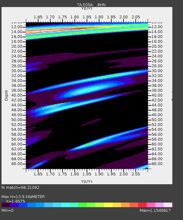
| Estimated Moho Depth: |
13.5 km |
| Estimated Crust Vp/Vs: |
1.66 |
| Assumed Crust Vp: |
6.597 km/s |
| Estimated Crust Vs: |
3.98 km/s |
| Estimated Crust Poisson's Ratio: |
0.21 |
|
| Radial Match: |
86.21092 % |
| Radial Bump: |
400 |
| Transverse Match: |
74.16278 % |
| Transverse Bump: |
400 |
| SOD ConfigId: |
2665 |
| Insert Time: |
2010-03-07 02:38:41.914 +0000 |
| GWidth: |
2.5 |
| Max Bumps: |
400 |
| Tol: |
0.001 |
|
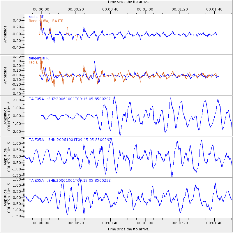
Signal To Noise
| Channel | StoN | STA | LTA |
| TA:E05A: :BHN:20061001T09:15:05.850029Z | 1.8489261 | 4.328839E-7 | 2.3412721E-7 |
| TA:E05A: :BHE:20061001T09:15:05.850029Z | 1.2777729 | 2.0091868E-7 | 1.5724132E-7 |
| TA:E05A: :BHZ:20061001T09:15:05.850029Z | 3.7045112 | 7.811313E-7 | 2.1085947E-7 |
| Arrivals |
| Ps | 1.4 SECOND |
| PpPs | 5.1 SECOND |
| PsPs/PpSs | 6.6 SECOND |


