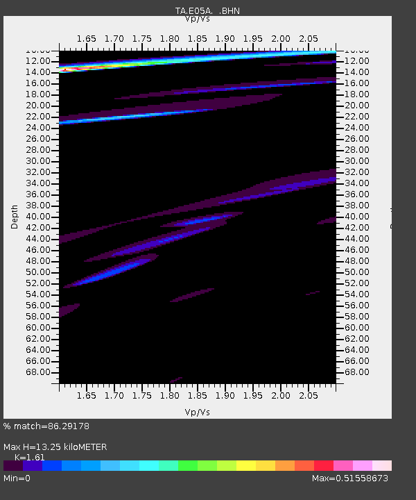
E05A Randle, WA, USA - Earthquake Result Viewer
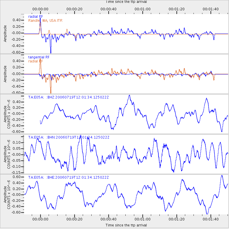
Earthquake location: New Britain Region, P.N.G.
Earthquake latitude/longitude: -5.5/150.7
Earthquake time(UTC): 2006/07/19 (200) 11:48:58 GMT
Earthquake Depth: 28 km
Earthquake Magnitude: 5.6 MB, 6.4 MS, 6.4 MW, 6.3 MW
Earthquake Catalog/Contributor: WHDF/NEIC
Network: TA USArray Transportable Network (new EarthScope stations)
Station: E05A Randle, WA, USA
Lat/Lon: 46.56 N/121.76 W
Elevation: 451 m
Distance: 92.3 deg
Az: 43.624 deg
Baz: 264.48 deg
Ray Param: 0.041479807
Estimated Moho Depth: 13.25 km
Estimated Crust Vp/Vs: 1.61
Assumed Crust Vp: 6.597 km/s
Estimated Crust Vs: 4.098 km/s
Estimated Crust Poisson's Ratio: 0.19
Radial Match: 86.29178 %
Radial Bump: 357
Transverse Match: 70.15291 %
Transverse Bump: 396
SOD ConfigId: 2665
Insert Time: 2010-03-07 02:38:56.482 +0000
GWidth: 2.5
Max Bumps: 400
Tol: 0.001

Signal To Noise

ChannelStoNSTALTA
TA:E05A: :BHN:20060719T12:01:34.125022Z1.53001648.518479E-85.5675734E-8
TA:E05A: :BHE:20060719T12:01:34.125022Z1.16422762.4287894E-72.086181E-7
TA:E05A: :BHZ:20060719T12:01:34.125022Z1.17194961.759501E-71.5013453E-7
Arrivals
Ps1.3 SECOND
PpPs5.1 SECOND
PsPs/PpSs6.4 SECOND