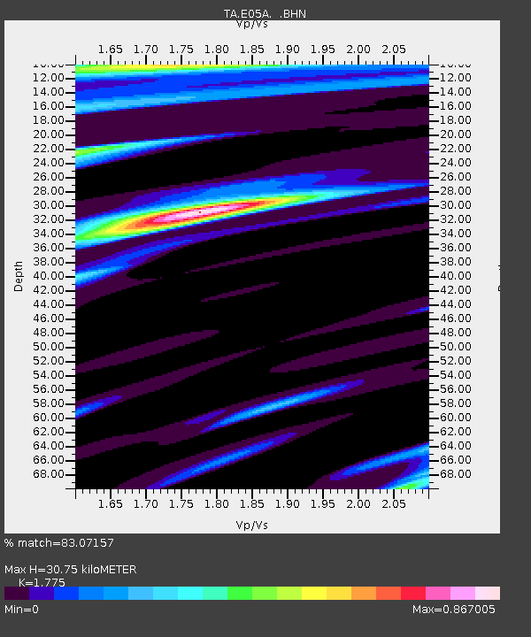
E05A Randle, WA, USA - Earthquake Result Viewer
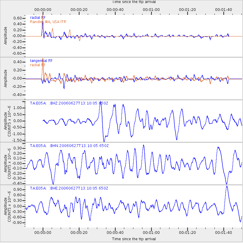
Earthquake location: Off Coast Of Chiapas, Mexico
Earthquake latitude/longitude: 15.0/-94.2
Earthquake time(UTC): 2006/06/27 (178) 13:03:12 GMT
Earthquake Depth: 29 km
Earthquake Magnitude: 5.4 MB, 5.5 MS, 5.8 MW, 5.8 MW
Earthquake Catalog/Contributor: WHDF/NEIC
Network: TA USArray Transportable Network (new EarthScope stations)
Station: E05A Randle, WA, USA
Lat/Lon: 46.56 N/121.76 W
Elevation: 451 m
Distance: 39.0 deg
Az: 329.515 deg
Baz: 134.715 deg
Ray Param: 0.07516854
Estimated Moho Depth: 30.75 km
Estimated Crust Vp/Vs: 1.77
Assumed Crust Vp: 6.597 km/s
Estimated Crust Vs: 3.717 km/s
Estimated Crust Poisson's Ratio: 0.27
Radial Match: 83.07157 %
Radial Bump: 400
Transverse Match: 70.360306 %
Transverse Bump: 400
SOD ConfigId: 2665
Insert Time: 2010-03-07 02:39:00.579 +0000
GWidth: 2.5
Max Bumps: 400
Tol: 0.001

Signal To Noise

ChannelStoNSTALTA
TA:E05A: :BHN:20060627T13:10:05.650Z1.62838981.308153E-78.033414E-8
TA:E05A: :BHE:20060627T13:10:05.650Z3.06772023.0721685E-71.00145E-7
TA:E05A: :BHZ:20060627T13:10:05.650Z7.6989479.613166E-71.2486338E-7
Arrivals
Ps3.9 SECOND
PpPs12 SECOND
PsPs/PpSs16 SECOND