You are here: Home > Network List > TA - USArray Transportable Network (new EarthScope stations) Stations List
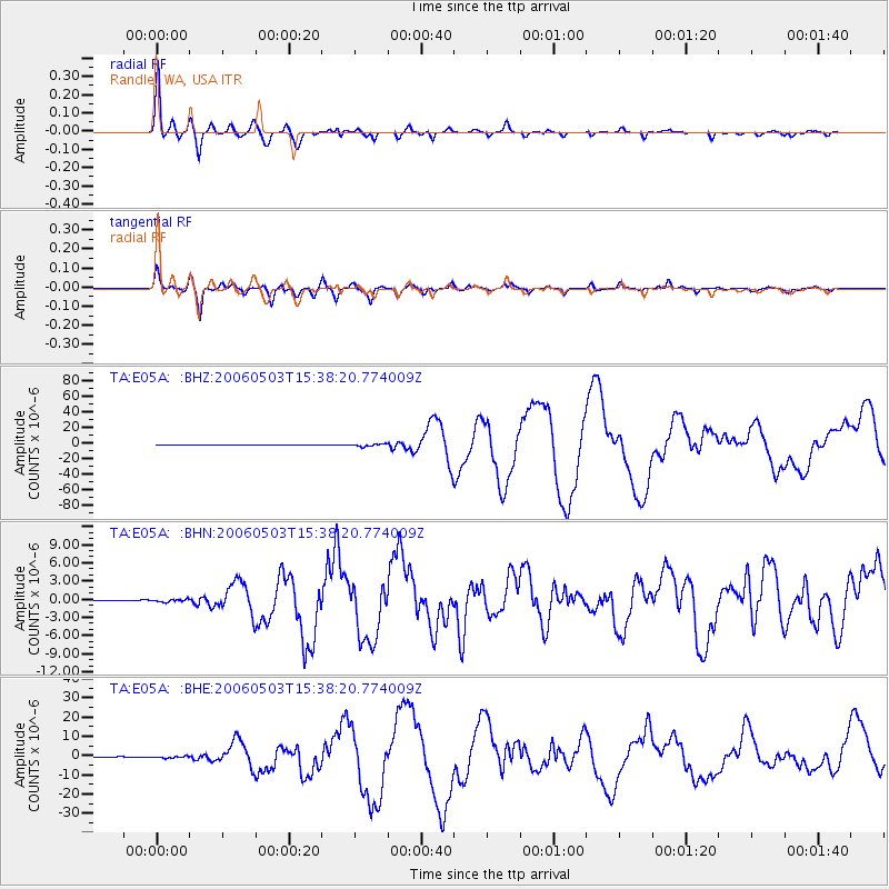
> Station E05A Randle, WA, USA > Earthquake Result Viewer
E05A Randle, WA, USA - Earthquake Result Viewer
| Earthquake location: |
Tonga Islands |
| Earthquake latitude/longitude: |
-20.2/-174.1 |
| Earthquake time(UTC): |
2006/05/03 (123) 15:26:40 GMT |
| Earthquake Depth: |
55 km |
| Earthquake Magnitude: |
7.2 MB, 7.8 MS, 7.9 MW, 7.9 MW |
| Earthquake Catalog/Contributor: |
WHDF/NEIC |
|
| Network: |
TA USArray Transportable Network (new EarthScope stations) |
| Station: |
E05A Randle, WA, USA |
| Lat/Lon: |
46.56 N/121.76 W |
| Elevation: |
451 m |
|
| Distance: |
81.5 deg |
| Az: |
33.536 deg |
| Baz: |
228.77 deg |
| Ray Param: |
0.047428373 |
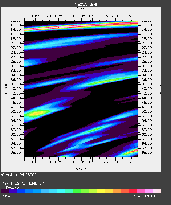
| Estimated Moho Depth: |
12.75 km |
| Estimated Crust Vp/Vs: |
1.75 |
| Assumed Crust Vp: |
6.597 km/s |
| Estimated Crust Vs: |
3.77 km/s |
| Estimated Crust Poisson's Ratio: |
0.26 |
|
| Radial Match: |
96.95882 % |
| Radial Bump: |
400 |
| Transverse Match: |
94.41598 % |
| Transverse Bump: |
400 |
| SOD ConfigId: |
2669 |
| Insert Time: |
2010-03-07 02:39:11.813 +0000 |
| GWidth: |
2.5 |
| Max Bumps: |
400 |
| Tol: |
0.001 |
|
Signal To Noise
| Channel | StoN | STA | LTA |
| TA:E05A: :BHN:20060503T15:38:20.774009Z | 3.4920268 | 2.1392499E-7 | 6.1260984E-8 |
| TA:E05A: :BHE:20060503T15:38:20.774009Z | 3.0084813 | 4.4150403E-7 | 1.4675312E-7 |
| TA:E05A: :BHZ:20060503T15:38:20.774009Z | 10.557064 | 1.5670454E-6 | 1.4843573E-7 |
| Arrivals |
| Ps | 1.5 SECOND |
| PpPs | 5.2 SECOND |
| PsPs/PpSs | 6.7 SECOND |


