You are here: Home > Network List > TA - USArray Transportable Network (new EarthScope stations) Stations List
> Station E05A Randle, WA, USA > Earthquake Result Viewer
E05A Randle, WA, USA - Earthquake Result Viewer
| Earthquake location: |
Near Coast Of Northern Chile |
| Earthquake latitude/longitude: |
-27.0/-71.0 |
| Earthquake time(UTC): |
2006/04/30 (120) 19:17:17 GMT |
| Earthquake Depth: |
27 km |
| Earthquake Magnitude: |
6.0 MB, 6.4 MS, 6.7 MW, 6.6 MW |
| Earthquake Catalog/Contributor: |
WHDF/NEIC |
|
| Network: |
TA USArray Transportable Network (new EarthScope stations) |
| Station: |
E05A Randle, WA, USA |
| Lat/Lon: |
46.56 N/121.76 W |
| Elevation: |
451 m |
|
| Distance: |
86.4 deg |
| Az: |
327.604 deg |
| Baz: |
136.156 deg |
| Ray Param: |
0.044019934 |
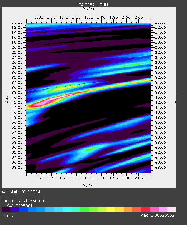
| Estimated Moho Depth: |
39.5 km |
| Estimated Crust Vp/Vs: |
1.73 |
| Assumed Crust Vp: |
6.597 km/s |
| Estimated Crust Vs: |
3.808 km/s |
| Estimated Crust Poisson's Ratio: |
0.25 |
|
| Radial Match: |
81.18876 % |
| Radial Bump: |
345 |
| Transverse Match: |
77.37776 % |
| Transverse Bump: |
396 |
| SOD ConfigId: |
2669 |
| Insert Time: |
2010-03-07 02:39:13.666 +0000 |
| GWidth: |
2.5 |
| Max Bumps: |
400 |
| Tol: |
0.001 |
|
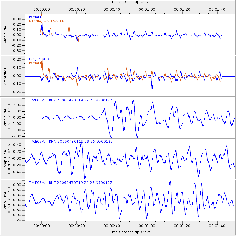
Signal To Noise
| Channel | StoN | STA | LTA |
| TA:E05A: :BHN:20060430T19:29:25.950012Z | 1.5169512 | 1.0726888E-7 | 7.071347E-8 |
| TA:E05A: :BHE:20060430T19:29:25.950012Z | 0.22890434 | 7.7818115E-8 | 3.399591E-7 |
| TA:E05A: :BHZ:20060430T19:29:25.950012Z | 1.382905 | 3.2311578E-7 | 2.3365003E-7 |
| Arrivals |
| Ps | 4.5 SECOND |
| PpPs | 16 SECOND |
| PsPs/PpSs | 20 SECOND |


