You are here: Home > Network List > TA - USArray Transportable Network (new EarthScope stations) Stations List
> Station E05A Randle, WA, USA > Earthquake Result Viewer
E05A Randle, WA, USA - Earthquake Result Viewer
| Earthquake location: |
Kermadec Islands Region |
| Earthquake latitude/longitude: |
-29.6/-176.8 |
| Earthquake time(UTC): |
2006/03/31 (090) 13:21:00 GMT |
| Earthquake Depth: |
17 km |
| Earthquake Magnitude: |
5.9 MB, 6.7 MS, 6.5 MW, 6.5 MW |
| Earthquake Catalog/Contributor: |
WHDF/NEIC |
|
| Network: |
TA USArray Transportable Network (new EarthScope stations) |
| Station: |
E05A Randle, WA, USA |
| Lat/Lon: |
46.56 N/121.76 W |
| Elevation: |
451 m |
|
| Distance: |
90.7 deg |
| Az: |
34.452 deg |
| Baz: |
225.558 deg |
| Ray Param: |
0.041655697 |
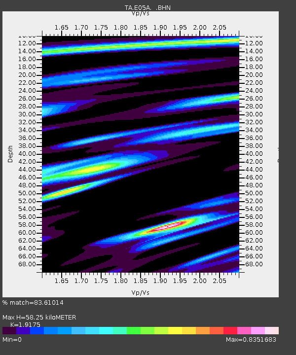
| Estimated Moho Depth: |
58.25 km |
| Estimated Crust Vp/Vs: |
1.92 |
| Assumed Crust Vp: |
6.597 km/s |
| Estimated Crust Vs: |
3.441 km/s |
| Estimated Crust Poisson's Ratio: |
0.31 |
|
| Radial Match: |
83.61014 % |
| Radial Bump: |
400 |
| Transverse Match: |
70.743675 % |
| Transverse Bump: |
400 |
| SOD ConfigId: |
132717 |
| Insert Time: |
2010-03-07 02:39:17.754 +0000 |
| GWidth: |
2.5 |
| Max Bumps: |
400 |
| Tol: |
0.001 |
|
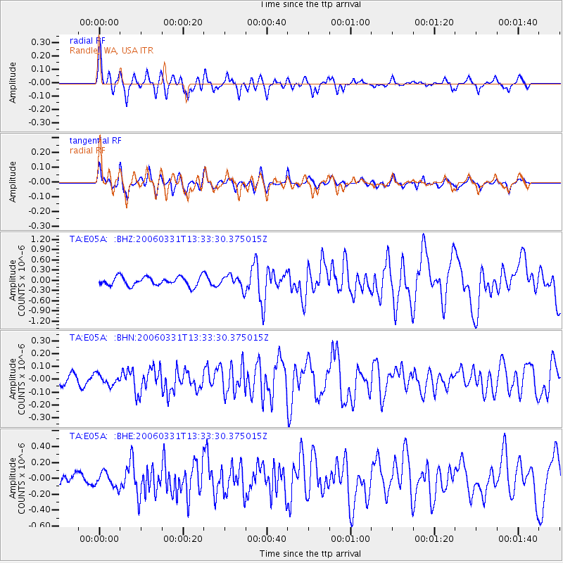
Signal To Noise
| Channel | StoN | STA | LTA |
| TA:E05A: :BHN:20060331T13:33:30.375015Z | 0.95420605 | 3.981467E-8 | 4.1725443E-8 |
| TA:E05A: :BHE:20060331T13:33:30.375015Z | 0.57017577 | 9.449889E-8 | 1.6573641E-7 |
| TA:E05A: :BHZ:20060331T13:33:30.375015Z | 1.4910218 | 1.947876E-7 | 1.3064036E-7 |
| Arrivals |
| Ps | 8.3 SECOND |
| PpPs | 25 SECOND |
| PsPs/PpSs | 34 SECOND |


