S09A Goldfield, NV, USA - Earthquake Result Viewer
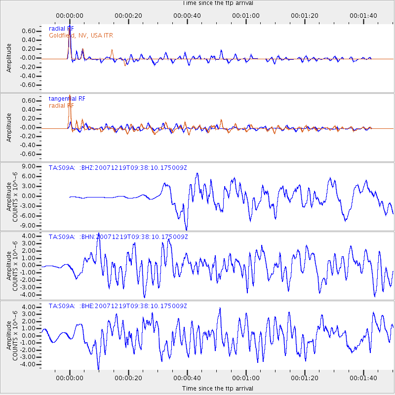
Earthquake location: Andreanof Islands, Aleutian Is.
Earthquake latitude/longitude: 51.4/-179.5
Earthquake time(UTC): 2007/12/19 (353) 09:30:27 GMT
Earthquake Depth: 29 km
Earthquake Magnitude: 6.4 MB, 7.1 MS, 7.1 MW, 7.0 MW
Earthquake Catalog/Contributor: WHDF/NEIC
Network: TA USArray Transportable Network (new EarthScope stations)
Station: S09A Goldfield, NV, USA
Lat/Lon: 37.72 N/117.23 W
Elevation: 1768 m
Distance: 45.1 deg
Az: 82.31 deg
Baz: 308.414 deg
Ray Param: 0.07144035
Estimated Moho Depth: 45.25 km
Estimated Crust Vp/Vs: 1.60
Assumed Crust Vp: 6.279 km/s
Estimated Crust Vs: 3.924 km/s
Estimated Crust Poisson's Ratio: 0.18
Radial Match: 91.80811 %
Radial Bump: 393
Transverse Match: 78.958115 %
Transverse Bump: 400
SOD ConfigId: 2564
Insert Time: 2010-03-07 02:39:22.081 +0000
GWidth: 2.5
Max Bumps: 400
Tol: 0.001

Signal To Noise

ChannelStoNSTALTA
TA:S09A: :BHN:20071219T09:38:10.175009Z3.04408939.325552E-73.063495E-7
TA:S09A: :BHE:20071219T09:38:10.175009Z2.32916551.0952347E-64.7022624E-7
TA:S09A: :BHZ:20071219T09:38:10.175009Z12.51936152.5121788E-62.006635E-7
Arrivals
Ps4.6 SECOND
PpPs18 SECOND
PsPs/PpSs22 SECOND