You are here: Home > Network List > UU - University of Utah Regional Network Stations List
> Station BRWY Blue Rim, WY, USA > Earthquake Result Viewer
BRWY Blue Rim, WY, USA - Earthquake Result Viewer
| Earthquake location: |
Near Coast Of Central Chile |
| Earthquake latitude/longitude: |
-34.2/-72.3 |
| Earthquake time(UTC): |
2019/08/01 (213) 18:28:05 GMT |
| Earthquake Depth: |
10 km |
| Earthquake Magnitude: |
6.8 mww |
| Earthquake Catalog/Contributor: |
NEIC PDE/us |
|
| Network: |
UU University of Utah Regional Network |
| Station: |
BRWY Blue Rim, WY, USA |
| Lat/Lon: |
41.62 N/109.50 W |
| Elevation: |
2098 m |
|
| Distance: |
82.9 deg |
| Az: |
332.804 deg |
| Baz: |
149.668 deg |
| Ray Param: |
0.04658239 |
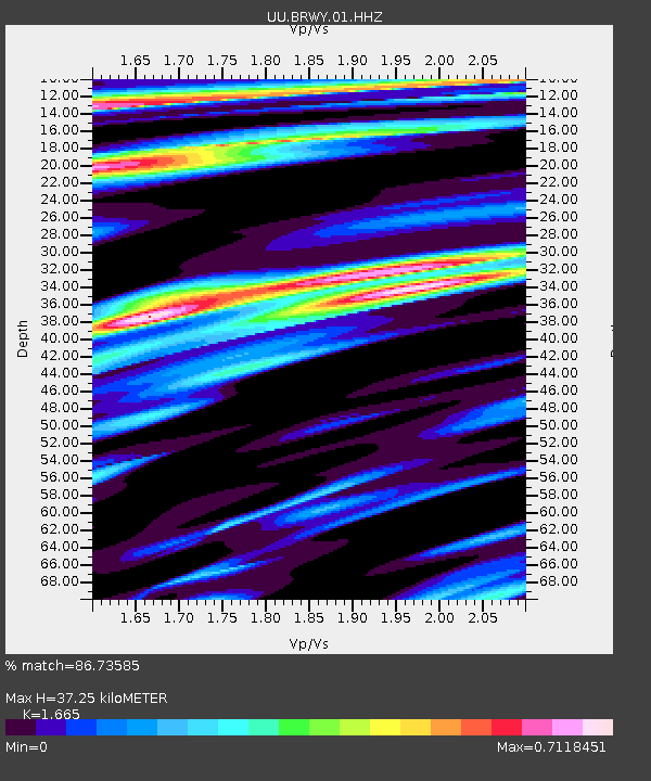
| Estimated Moho Depth: |
37.25 km |
| Estimated Crust Vp/Vs: |
1.66 |
| Assumed Crust Vp: |
6.207 km/s |
| Estimated Crust Vs: |
3.728 km/s |
| Estimated Crust Poisson's Ratio: |
0.22 |
|
| Radial Match: |
86.73585 % |
| Radial Bump: |
400 |
| Transverse Match: |
55.712654 % |
| Transverse Bump: |
400 |
| SOD ConfigId: |
19053131 |
| Insert Time: |
2019-08-15 18:37:59.873 +0000 |
| GWidth: |
2.5 |
| Max Bumps: |
400 |
| Tol: |
0.001 |
|

Signal To Noise
| Channel | StoN | STA | LTA |
| UU:BRWY:01:HHZ:20190801T18:39:58.470007Z | 6.7219973 | 1.6219245E-8 | 2.412861E-9 |
| UU:BRWY:01:HHN:20190801T18:39:58.470007Z | 1.0660292 | 1.3418412E-8 | 1.2587284E-8 |
| UU:BRWY:01:HHE:20190801T18:39:58.470007Z | 0.99643123 | 7.0414825E-9 | 7.066702E-9 |
| Arrivals |
| Ps | 4.1 SECOND |
| PpPs | 16 SECOND |
| PsPs/PpSs | 20 SECOND |


