You are here: Home > Network List > UU - University of Utah Regional Network Stations List
> Station HMU Henry Mountain, UT, USA > Earthquake Result Viewer
HMU Henry Mountain, UT, USA - Earthquake Result Viewer
| Earthquake location: |
Near Coast Of Central Chile |
| Earthquake latitude/longitude: |
-34.2/-72.3 |
| Earthquake time(UTC): |
2019/08/01 (213) 18:28:05 GMT |
| Earthquake Depth: |
10 km |
| Earthquake Magnitude: |
6.8 mww |
| Earthquake Catalog/Contributor: |
NEIC PDE/us |
|
| Network: |
UU University of Utah Regional Network |
| Station: |
HMU Henry Mountain, UT, USA |
| Lat/Lon: |
37.94 N/110.74 W |
| Elevation: |
2430 m |
|
| Distance: |
80.2 deg |
| Az: |
330.064 deg |
| Baz: |
148.475 deg |
| Ray Param: |
0.04843168 |
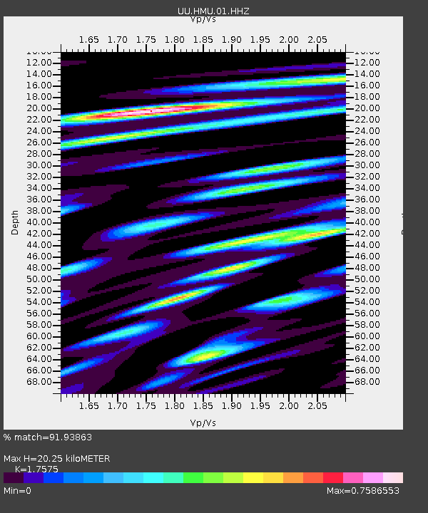
| Estimated Moho Depth: |
20.25 km |
| Estimated Crust Vp/Vs: |
1.76 |
| Assumed Crust Vp: |
6.247 km/s |
| Estimated Crust Vs: |
3.554 km/s |
| Estimated Crust Poisson's Ratio: |
0.26 |
|
| Radial Match: |
91.93863 % |
| Radial Bump: |
371 |
| Transverse Match: |
88.38601 % |
| Transverse Bump: |
400 |
| SOD ConfigId: |
19053131 |
| Insert Time: |
2019-08-15 18:38:06.296 +0000 |
| GWidth: |
2.5 |
| Max Bumps: |
400 |
| Tol: |
0.001 |
|

Signal To Noise
| Channel | StoN | STA | LTA |
| UU:HMU:01:HHZ:20190801T18:39:44.428015Z | 6.2623754 | 1.1908883E-8 | 1.901656E-9 |
| UU:HMU:01:HHN:20190801T18:39:44.428015Z | 2.5859885 | 4.669099E-9 | 1.8055373E-9 |
| UU:HMU:01:HHE:20190801T18:39:44.428015Z | 1.7360058 | 3.5884242E-9 | 2.0670576E-9 |
| Arrivals |
| Ps | 2.5 SECOND |
| PpPs | 8.7 SECOND |
| PsPs/PpSs | 11 SECOND |


