You are here: Home > Network List > TA - USArray Transportable Network (new EarthScope stations) Stations List
> Station S09A Goldfield, NV, USA > Earthquake Result Viewer
S09A Goldfield, NV, USA - Earthquake Result Viewer
| Earthquake location: |
East Of Kuril Islands |
| Earthquake latitude/longitude: |
46.5/154.7 |
| Earthquake time(UTC): |
2006/11/15 (319) 11:40:55 GMT |
| Earthquake Depth: |
10 km |
| Earthquake Magnitude: |
6.4 MB |
| Earthquake Catalog/Contributor: |
WHDF/NEIC |
|
| Network: |
TA USArray Transportable Network (new EarthScope stations) |
| Station: |
S09A Goldfield, NV, USA |
| Lat/Lon: |
37.72 N/117.23 W |
| Elevation: |
1768 m |
|
| Distance: |
62.7 deg |
| Az: |
63.132 deg |
| Baz: |
308.981 deg |
| Ray Param: |
0.060073227 |
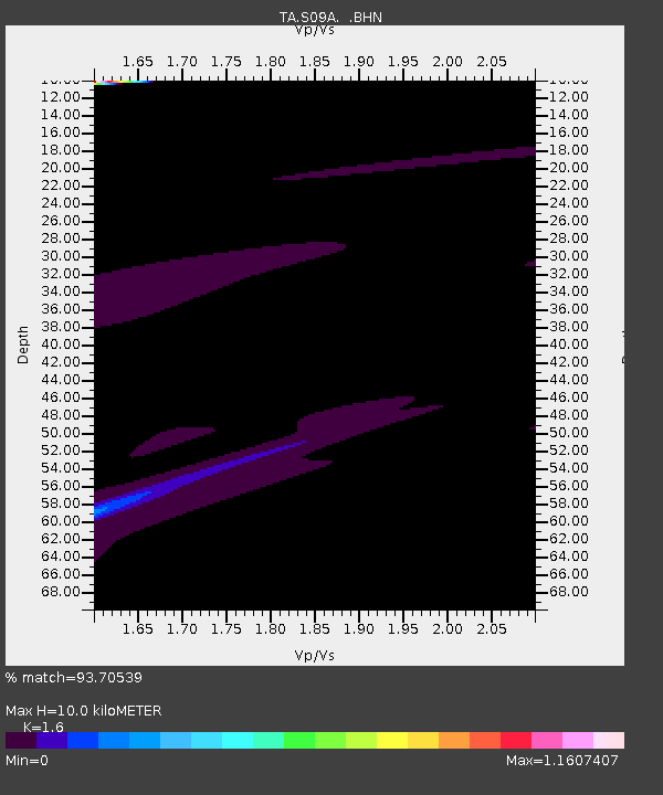
| Estimated Moho Depth: |
10.0 km |
| Estimated Crust Vp/Vs: |
1.60 |
| Assumed Crust Vp: |
6.279 km/s |
| Estimated Crust Vs: |
3.924 km/s |
| Estimated Crust Poisson's Ratio: |
0.18 |
|
| Radial Match: |
93.70539 % |
| Radial Bump: |
400 |
| Transverse Match: |
87.60247 % |
| Transverse Bump: |
400 |
| SOD ConfigId: |
2564 |
| Insert Time: |
2010-03-07 02:39:36.602 +0000 |
| GWidth: |
2.5 |
| Max Bumps: |
400 |
| Tol: |
0.001 |
|

Signal To Noise
| Channel | StoN | STA | LTA |
| TA:S09A: :BHN:20061115T11:50:48.648022Z | 1.1015052 | 8.986046E-5 | 8.1579696E-5 |
| TA:S09A: :BHE:20061115T11:50:48.648022Z | 1.9672108 | 1.4374102E-4 | 7.306844E-5 |
| TA:S09A: :BHZ:20061115T11:50:48.648022Z | 1.1499975 | 1.1256201E-4 | 9.788022E-5 |
| Arrivals |
| Ps | 1.0 SECOND |
| PpPs | 4.0 SECOND |
| PsPs/PpSs | 5.0 SECOND |


